
Bad Timing in Brush
13 Jun 9
Morgan County, CO
SHORT: Intercepted briefly tornadic supercell near Ft. Morgan and Brush CO that evolved out of nondescript storm band.
LONG:
We left the DEN area about the time a severe storm rolled out of the adjacent mountains toward Broomfield. At the time we still were undecided as to whether to head to a distant and receding storm in SE WY moving into an apparently better environment near the NEb border, or stick around northern CO for the closer activity and hope conditions (namely low level shear) would improve with time in the projected path.
We hit Greeley, the no-turning-back point, and decided it would take at least 2.5 hours to get to the area where the WY storms would be in west NEb, if they still existed. So…instead, we chose to go E to get ahead of the discretely propagating multicell cluster slithering NE out of the Colorado metromess.
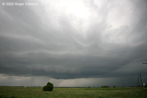
We set up about 15 NE of Brush to give the convective slop to our SW and W time to evolve, then pick a “best storm”. For a long time, the storms looked like speckled, disorganized rubbish, nothing rotating, or with only brief, short and weak bouts of cyclonic shear. Cells developed overhead and moved N, merging into a band that extended from NNE-WSW of us. Meanwhile a promising looking cell formed to our NE on the CYS Ridge, closest to the maximized 0-1 km SRH, and tempted us…until it took a hard left turn and started charging due N past SNY. All these storms had low cloud bases for Colorado, and the farthest ones looked more distant than they were.
We spent an hour or more of waiting for all these junky looking storms to do something, while petting a friendly quarter horse and feeding it green grass and apples. Finally, we noticed that the southwestern cell in the band (WNW of Ft. Morgan) started to sport a base with persistent scuddy lowerings. It also began showing cyclonic shear in lowest-cut SRMs. Off we went!
By the time we got to our first vantage near Brush, it had a pronounced supercell look, with tail-cloud banding, and intermittent, small wall clouds near the notch area. At times the structure was classical, but not as wildly sculpted nor brilliantly contrasted as the Arkansas Valley storms a couple days before. Photogenically, this supercell was underwhelming. It lay constantly under heavy anvil canopy, with junky storms upshear. Little occlusions and wall clouds came and went, a few with fairly rapid rising motion and/or cyclonic shear at cloud base.
Several crappy showers formed in the inflow region, atop us, and rained within already cool-feeling air. They dropped the sfc temps to the low-mid 60s F, and appeared to mess with the Ft. Morgan storm’s morphology for awhile, cycling down the wall cloud production and giving it a flat, strung-out and cold looking base. But then those stupid showers drifted off to the NE, and storm organization improved again.
We observed and took photos of the storm for two rather long periods of stops near Brush. I’ve got photos up to 1844 MDT and beginning again at 1914 MDT, although we had a good view of the storm for all but a few minutes in between while driving and hunting for vantage. Those few minutes? The time of Bill R’s and Scott L’s tornado observation matches the short interval we were passing through the town, repositioning to get closer; therefore, we didn’t see the tornado.
Afterward, we were closer, watching a series of quick occlusions and RFD cuts interspersed with rapid cloud base motions. At one point, a needle funnel appeared for maybe 20 seconds (driving…no photo), and one or two other ragged but at least weakly rotating funnels showed up later. At no point after 1914 MDT did we see firm evidence of a tornado, though we saw a few brief episodes of strong cloud base motion while we drove essentially abeam of the storm, up US-6, NE of Brush.
It was getting dark, and the new anchor storms to our SW looked like outflow-dominant garbage (despite the “law enforcement” report of a funnel therewith…cop probably was psyched out by the earlier, legitimate storm). The anchor storms barfed a cold load, estimated outflow winds of up to 50 mph blasting past the windows where we ate dinner at Brush.
Too tired from a long day of car repairs, laundry, phone calls home, and chasing, we decided not to go back to DEN for the night, only to head back out at least as far E the next day.
Instead, we snagged a tax free room at a cheap motel in the area. I love that kind of deal. The old man at the desk was funny: “The rate’s $40 plus tax with a credit card, or just $40 with cash.” Well then, we agreed…hell with the tax man! Unfortunately, their advertised “Hi-Speed Internet” didn’t work at all, so I used my I-Phone for online stuff. I love the device, but no way am I writing any posts from that…too awkward — “keys” too small, fingers too big.
As lame as things looked for the longest time, I was glad to salvage an interesting supercell with cyclic occlusions and funnels, and chalked up missing the brief tornado to just another instance of what’s happened several times before. I’m accustomed to it. I would have been more upset missing a sig-event, which clearly this wasn’t. If the storm hadn’t ingested that rainy air from the junk showers, I’m convinced it could have done more, sooner, and for longer. We were farther E and had stronger sfc winds than the other chasers I know, for much of the supercell’s pre-tornadic lifespan; and it seemed the main inflow channel was E of the storm.
Arkansas Valley Supercells of Colorado
Filed under: Summary
11 Jun 9
Olney Springs to Lamar, CO
SHORT: Four supercells and one possible/weak “cheezenado” photographed in and near Colorado’s Arkansas River valley between PUB-LAA. Jaw-dropping storm structure at times.
LONG:
Elke and I again formed a caravan with the Two Fogels/Two Dogs chase team. We targeted a compromise area of eastern CO near the Palmer Divide, in order to remain within reach of almost any possible initiation area.
V.O.R.T.EX.-2 and the Bovine Butt Spew
Off toward LIC we went, but not before seeing a practically ceaseless stream of V.O.R.T.EX.-2 vehicles cruising with apparently focused determination SE past LBL. I asked Elke (and also DF over the radio):”Where the hell are they going, and why?” At first we were quite puzzled, but ignored what we saw and just kept on with our northwestern bearing. I later guessed (correctly, for once) that they were targeting a very conditional tornado potential in the eastern Texas Panhandle.
One lesser-known hazard to dodge while chasing: bovine diarrhea. In Scott City, some moo-cow on the second deck of a cattle truck blasted a brown liquid cascade out of one of the ventilation holes, staright down toward us. The side of the truck was covered with similarly colored fans of dried residue emanating from the same general area. We were quite thankful that later rain washed off any related residue from my vehicle.
As we headed W on I-70 toward LIC, we noted that early-initiation over the Front Range already was getting messy and turning into a conglomeration of storms. You know what that means on the high plains of Colorado: outflowus barfus windbaggus. One really nicely spiraled bow echo, evident in reflectivity imagery NW of LIC, told us all we needed to know about the potential N of the Palmer Ridge: zilch, nyet, nein, nada, (and for Joisey boys like DF) fuhgeddaboutit.
Southward we plunged toward Ordway and the remaining area of relatively high CAPE and backed sfc winds in the Arkansas River Valley. As we did so, we passed through some outflow from Palmer Ridge storms, and…BRR! Get the polar bear parkas out — 47 degrees F…no thanks! As did the cow before, now did the atmosphere there.
A Tale of Two Supercells
Shortly N of Ordway, a solitary, compact, well organized storm became apparent visually and on radar to the distant SW, over Hodo’s hometown and well removed from that wretched outflow pile to our N. We could see a broad updraft base in the distance, and even a ragged wall cloud attempt or two as it was exiting the PUB area.
We set up 2 NNE Olney Springs to let the storm (Storm 1) come toward us, occasionally photographing the broad but rather featureless updraft base, while DF’s big dogs played in the roadside dirt and weeds. The storm seemed to be drawing in a blended boundary comprised of a cumuliform banded horizontal convective roll (one of several HCRs appearing in reflectivity imagery and evident with eyeballs) and a differential heating zone under the anvil. Might these have contributed to its eventual dominance and longevity somehow?
As Storm 1 chugged along toward us, another supercell (Storm 2) quickly developed nearer to us, and to the SW. Within half an hour, it went from mere towers to a banded and visibly rotating storm with a nice precip cascade from the forward-flank, anvil/vault region. We thought Storm 2 would screw up Storm 1 (wide angles looking SW and looking NW respectively, from near Manzanola), but for the next 1.5-2 hours, they marched along the valley in tandem, often merged at 40-50 dBZ on radar but visually distinct, both sporting occasional rotating wall clouds of verying sizes (wide angles looking SW and looking NW respectively, from W of Rocky Ford) and nicely banded/vaulted structures.
We cruised down US-50 a step ahead of this rotating tandem of tempestuous tumult, stopping for photos of both these storms in several locales. Their structure got more amazing each time, and I often found myself turning N-NW for Storm 1, then WSW for Storm 2, then back and forth again. Double the flavor and double the refreshment! I was longing for two sticks of Doublemint. 😉
Spectacular Storms Multiply and Merge
Another supercell formed SW of Storm 2 (we’ll call it Storm 3), also exhibiting a vaulted and somewhat banded appearance for a short time. Storm 3 (here seen “below” — actually beyond — storm 2) would get undercut by the RFD outflow trailing behind Storm 2. Storm 4 formed as a short-lived supercell with obvious cyclonic shear in SRM imagery, almost under the anvil precip from Storm 1. Storm 4 lasted just long enough to produce a very low hanging wall cloud well NNE of Hadley, which I also shot from a great vantage of all the storms 2 WSW Hadley.
Hot diggity dawg…supercells galore, and we were seeing them all! Party time in the Arkansas Valley — that is, unless one was a corn grower.
From that same spot, we let Storm 2 approach and the almost completely connected Storm 1 move to our N, each of which also was closing in on the other. The whole interaction, visually, reminded me of football where the safety “angles toward” the flanker running down the sideline, except in this case, the two would merge into one uber-player, instead of one knocking the other out of bounds.
Storm 4 soon got overwhelmed by forward-flank precip from Storm 1, which still was spinning along nicely despite its Siamese twin relationship with Storm 2. At times a thick cloud band connected them, as if they were born partners in serving up a multi-course meal on the smorgasbord of spectacular skies (and atmospheric violence in the form of gorilla hail, for those unfortunate enough to endure their cores).
Probably a Weak, Cheesy Tornado
As the two supercells began merging near Hadley, the easily identifiable remains of Storm 2 just to our W and the more dominant Storm 1 to our N, a peculiar event happened that you may have noticed in the bottom-middle of the last shot (super enhanced crop-zoom thereof).
That feature was rotating, and very obviously — a tapered, helically spinning and rapidly rising column of occasionally smooth, sometimes ragged and always rapidly evolving cloud material right under the Storm 1 wall cloud (another super-enhanced crop). Time was 0038Z, distance was about 4-5 N of Highway 50 and NW of Hadley. We didn’t see debris, but for a very brief time, had ragged condensational connectivity with both ground and wall cloud. If it was a tornado, as also suspected by a couple of other trustworthy observers I know who were located to its SE and E, it was a cheesy and inconsequential one; and nothing to get too excited about. Still, I’m about 80% confident this was a weak tornado.
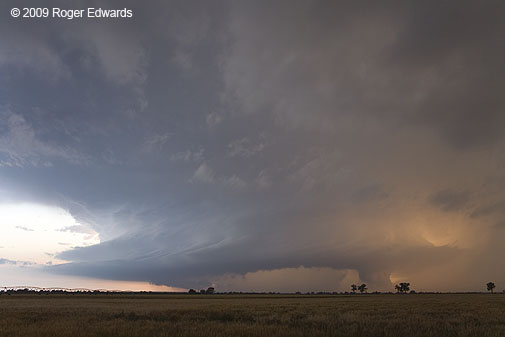
The Storminator
Contrary to my earlier hypothesis, Storm 1 (the old PUB supercell) took over and gradually absorbed Storm 2, turning in an absolutely jaw-dropping, prolonged display of structural delights, beginning near Las Animas soon after the merger. The combined storm, which mostly was the original Storm 1, liberally festooned itself with bands, striations, differential light effects, and occasional strongly rotating wall clouds wrapping up on its N side. These wall clouds quickly would get enshrouded in precip-filled occlusions downdraft cuts that coiled completely around their front (E and NE) sides, as viewed from the ENE on Highway 50 between Ft. Lyon and Hasty.
All the while, we blasted through one memory card after another shooting the amazing visual show at wide angles, sometimes zooming into another short-lived but rotating wall cloud. For a short time, the N side of what now was the only remaining storm (Storm 1) lit golden and orange in the setting sun W of LAA, while a very low-hanging and rotating wall cloud dangled beneath the N side of the spiralling pinwheel of supercellular glory.
Finishing up in Lamar: No Rats or Roaches
We let the storm go at LAA due to darkness, grabbed a $44 (incl. tax) room that (unlike the field project’s nearby accommodations) did not have spiders, roaches and mice. We then had a nice dinner at a restaurant in LAA. The place was about to close as we walked in…but stayed open at my request to feed a large number of arriving chasers after hours — including people pulling up from Bill Reid’s and Charles Edwards’ tour groups, a V.O.R.T.EX.-2 stereo-videography subgroup led by Jim LaDue, and us. It was good to see Dave Lewison and Rocky again, along with photographer extraordinaire Brian Morganti.
We also saw Mikes Foster and Coniglio there. They, as well as Mr. LaDue, let me know that the project had gone down to Canadian before doubling back, confirming my earlier suspicions. Boy, did V2 ever put in a long day. Several of them saw us turning N out of LBL as they headed SE, and perhaps wondered what the hell we were thinking. 😀
What a fantastic and rewarding chase. It was the second day in a row of gorgeous, sculpted storms out of two days so far on the High Plains. This is why we love to be up there, west of 100W. If the season ended then, we would have been content, but in the end, we were very glad it didn’t!
Wyoming-Nebraska Tornadic Supercell
Filed under: Summary, Uncategorized
5 Jun 9, Bushnell to Gurley NEb
SHORT: Intercepted mature supercell with tornado in progress in SErn Goshen County WY, looking NW from N of Bushnell NE. Spectacular rope-out followed by several structure photography stops over the course of a few hours, before landing in OGA for the night.
LONG: We began the day in HYS after driving up from Norman the day before, when I had no sleep all night the 3rd or all day the 4th. We slept in at HYS as a result…maybe a little too long. The target area was fairly well focused — the CYS Ridge region and any convection that might erupt off the southern LAR range. Unfortunately for us, the farthest possible zone within the target area was where it erupted, but we managed to salvage the day anyway.
Flat “pancakus” Cu hovered over the CYS ridge to our N as we approached Wray CO, with dense cirrus overhead limiting heating. Meanwhile some small echoes began to appear near the LAR range NW of CYS. After a quick service stop in Holyoke, one of those echoes (the eventual La Grange WY storm) was starting to get a compact and intense core, with no apparent sources of convective interference to its S,either in VIS or reflectivity imagery. Off we torn. By now the storm was starting to look supercellular on radar, and we had to haul west on I-80.
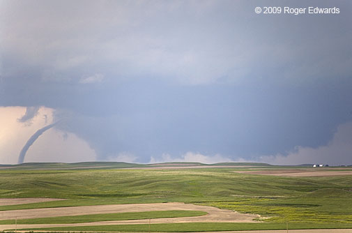
Once we got past SNY, a darkened, elongated smudge appeared under the cirrus deck to our WNW, and tornado warnings began. Keith had called DF to let him know that the storm was about to produce, and we made good time along the Interstate toward the WY border. We turned N through Bushnell onto a road that DeLorme indicated was paved…but it became gravel and hard-packed dirt.
About 2-3 N of Bushnell and barely E of the WY border, we began to see the tornado on the SW edge of a broad wall cloud — a nearly vertical stovepipe with some precip and/or dust around the condensation funnel. By the time we found a good vantage a few minutes later — a hillside ~5 N of Bushnell, the tornado began to narrow into a tapered, curved cone. By the time I pulled over, got out, ran to the other side of the road and hoisted the camera, it already was in transition through elephant-trunk (wide-angle and with zoom lens) to rope stage, at the S edge of a gigantic, ragged wall cloud.
This was Emily’s very first tornado, which earned her a vigorous high-5 from me. It also was Elke’s third birthday tornado, a most fitting atmospheric present for her. Finally, this was the second time that Elke, DF and I had seen a tornado in one state from a different state (the other being in Montana but seen from North Dakota on 6 Jun 5, the infamous “Ekalaka Smacka Backa” chase). We admired and photographed the narrowing then roping tube from a distance, watching the sinewy condensation funnel rope out in a spectacular arc, then finally split into segments and die quickly. We had seen a little under half of its lifetime, based on others’ accounts. After the long and pounding haul from HYS, we felt very fortunate to see even the last 7-8 minutes of its lifetime.
We then headed E on some unmarked, mainly gravel roads, eventually meeting up with some folks including Hodo, MattC, Rocky, Charles, Alnado, and a few others who had the privelege of witnessing the tornado from closer and/or longer time. We also had the pleasure of talking with Dave Hoadley, who saw the last few minutes of the tornado from even farther away, N of Kimball. Gotta love that long High Plains visibility!
After it paid the tornado troll’s toll for entry into Nebraska, the supercell as a whole became somewhat ragged, but still well-defined and visually pleasing. A couple of occlusions along the way E yielded moderately rotating wall clouds — one extruding a conical cloud lowering that spun slowly, as if trying to tighten into a funnel. Another lowering later, NNW of Kimball, briefly stretched into a ragged but definitely rotating funnel with no apparent debris beneath, way back in an old occlusion to the NNW (looking N under newer wall cloud).
We then got road-screwed and had to drop S to I-80, whereupon we bid farewell to DF and Emily (who had to fly out of ICT early the next morning), then headed back N out of SNY to watch the storm some more.
By the time we got back on it, near and E of Gurley, the supercell had acquired a messy underbelly with a ground-scraping wall cloud, beneath a highly tilted convective plume, and fronted by a skirt of striated cloud material. The storm cast a long, sharp shadow to the ESE while spinning over the beautifully verdant wheat fields of southwest Nebraska, and later, posing before a deployed sticknet.
Soon it was getting dark, so we went SE to OGA for the night, whereupon we got fast-food dinner and a motel room, then began hearing reports of nighttime tornadoes from “our storm”, headed right for OGA! We bailed S of town a few miles to spot. A new, tornado-warned supercell to our E took over and sent a raging pool of outflow toward us, killing the long-lived LaGrange-Gurley supercell at last.
We worked hard for everything we saw on this first chase day of the vacation, and slept well that night, bathed in gratitude and satisfaction for a pretty tornado and some grand displays of supercell formations along the way. What a fantastic way to start a grand June 2009 storm-observing odyssey across the Great Plains!