
Bad Timing in Brush
13 Jun 9
Morgan County, CO
SHORT: Intercepted briefly tornadic supercell near Ft. Morgan and Brush CO that evolved out of nondescript storm band.
LONG:
We left the DEN area about the time a severe storm rolled out of the adjacent mountains toward Broomfield. At the time we still were undecided as to whether to head to a distant and receding storm in SE WY moving into an apparently better environment near the NEb border, or stick around northern CO for the closer activity and hope conditions (namely low level shear) would improve with time in the projected path.
We hit Greeley, the no-turning-back point, and decided it would take at least 2.5 hours to get to the area where the WY storms would be in west NEb, if they still existed. So…instead, we chose to go E to get ahead of the discretely propagating multicell cluster slithering NE out of the Colorado metromess.
We set up about 15 NE of Brush to give the convective slop to our SW and W time to evolve, then pick a “best storm”. For a long time, the storms looked like speckled, disorganized rubbish, nothing rotating, or with only brief, short and weak bouts of cyclonic shear. Cells developed overhead and moved N, merging into a band that extended from NNE-WSW of us. Meanwhile a promising looking cell formed to our NE on the CYS Ridge, closest to the maximized 0-1 km SRH, and tempted us…until it took a hard left turn and started charging due N past SNY. All these storms had low cloud bases for Colorado, and the farthest ones looked more distant than they were.
We spent an hour or more of waiting for all these junky looking storms to do something, while petting a friendly quarter horse and feeding it green grass and apples. Finally, we noticed that the southwestern cell in the band (WNW of Ft. Morgan) started to sport a base with persistent scuddy lowerings. It also began showing cyclonic shear in lowest-cut SRMs. Off we went!
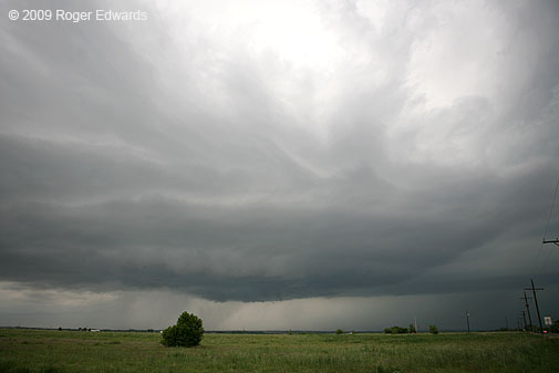
By the time we got to our first vantage near Brush, it had a pronounced supercell look, with tail-cloud banding, and intermittent, small wall clouds near the notch area. At times the structure was classical, but not as wildly sculpted nor brilliantly contrasted as the Arkansas Valley storms a couple days before. Photogenically, this supercell was underwhelming. It lay constantly under heavy anvil canopy, with junky storms upshear. Little occlusions and wall clouds came and went, a few with fairly rapid rising motion and/or cyclonic shear at cloud base.
Several crappy showers formed in the inflow region, atop us, and rained within already cool-feeling air. They dropped the sfc temps to the low-mid 60s F, and appeared to mess with the Ft. Morgan storm’s morphology for awhile, cycling down the wall cloud production and giving it a flat, strung-out and cold looking base. But then those stupid showers drifted off to the NE, and storm organization improved again.
We observed and took photos of the storm for two rather long periods of stops near Brush. I’ve got photos up to 1844 MDT and beginning again at 1914 MDT, although we had a good view of the storm for all but a few minutes in between while driving and hunting for vantage. Those few minutes? The time of Bill R’s and Scott L’s tornado observation matches the short interval we were passing through the town, repositioning to get closer; therefore, we didn’t see the tornado.
Afterward, we were closer, watching a series of quick occlusions and RFD cuts interspersed with rapid cloud base motions. At one point, a needle funnel appeared for maybe 20 seconds (driving…no photo), and one or two other ragged but at least weakly rotating funnels showed up later. At no point after 1914 MDT did we see firm evidence of a tornado, though we saw a few brief episodes of strong cloud base motion while we drove essentially abeam of the storm, up US-6, NE of Brush.
It was getting dark, and the new anchor storms to our SW looked like outflow-dominant garbage (despite the “law enforcement” report of a funnel therewith…cop probably was psyched out by the earlier, legitimate storm). The anchor storms barfed a cold load, estimated outflow winds of up to 50 mph blasting past the windows where we ate dinner at Brush.
Too tired from a long day of car repairs, laundry, phone calls home, and chasing, we decided not to go back to DEN for the night, only to head back out at least as far E the next day.
Instead, we snagged a tax free room at a cheap motel in the area. I love that kind of deal. The old man at the desk was funny: “The rate’s $40 plus tax with a credit card, or just $40 with cash.” Well then, we agreed…hell with the tax man! Unfortunately, their advertised “Hi-Speed Internet” didn’t work at all, so I used my I-Phone for online stuff. I love the device, but no way am I writing any posts from that…too awkward — “keys” too small, fingers too big.
As lame as things looked for the longest time, I was glad to salvage an interesting supercell with cyclic occlusions and funnels, and chalked up missing the brief tornado to just another instance of what’s happened several times before. I’m accustomed to it. I would have been more upset missing a sig-event, which clearly this wasn’t. If the storm hadn’t ingested that rainy air from the junk showers, I’m convinced it could have done more, sooner, and for longer. We were farther E and had stronger sfc winds than the other chasers I know, for much of the supercell’s pre-tornadic lifespan; and it seemed the main inflow channel was E of the storm.