
Arkansas Valley Supercells of Colorado
Filed under: Summary
11 Jun 9
Olney Springs to Lamar, CO
SHORT: Four supercells and one possible/weak “cheezenado” photographed in and near Colorado’s Arkansas River valley between PUB-LAA. Jaw-dropping storm structure at times.
LONG:
Elke and I again formed a caravan with the Two Fogels/Two Dogs chase team. We targeted a compromise area of eastern CO near the Palmer Divide, in order to remain within reach of almost any possible initiation area.
V.O.R.T.EX.-2 and the Bovine Butt Spew
Off toward LIC we went, but not before seeing a practically ceaseless stream of V.O.R.T.EX.-2 vehicles cruising with apparently focused determination SE past LBL. I asked Elke (and also DF over the radio):”Where the hell are they going, and why?” At first we were quite puzzled, but ignored what we saw and just kept on with our northwestern bearing. I later guessed (correctly, for once) that they were targeting a very conditional tornado potential in the eastern Texas Panhandle.
One lesser-known hazard to dodge while chasing: bovine diarrhea. In Scott City, some moo-cow on the second deck of a cattle truck blasted a brown liquid cascade out of one of the ventilation holes, staright down toward us. The side of the truck was covered with similarly colored fans of dried residue emanating from the same general area. We were quite thankful that later rain washed off any related residue from my vehicle.
As we headed W on I-70 toward LIC, we noted that early-initiation over the Front Range already was getting messy and turning into a conglomeration of storms. You know what that means on the high plains of Colorado: outflowus barfus windbaggus. One really nicely spiraled bow echo, evident in reflectivity imagery NW of LIC, told us all we needed to know about the potential N of the Palmer Ridge: zilch, nyet, nein, nada, (and for Joisey boys like DF) fuhgeddaboutit.
Southward we plunged toward Ordway and the remaining area of relatively high CAPE and backed sfc winds in the Arkansas River Valley. As we did so, we passed through some outflow from Palmer Ridge storms, and…BRR! Get the polar bear parkas out — 47 degrees F…no thanks! As did the cow before, now did the atmosphere there.
A Tale of Two Supercells
Shortly N of Ordway, a solitary, compact, well organized storm became apparent visually and on radar to the distant SW, over Hodo’s hometown and well removed from that wretched outflow pile to our N. We could see a broad updraft base in the distance, and even a ragged wall cloud attempt or two as it was exiting the PUB area.
We set up 2 NNE Olney Springs to let the storm (Storm 1) come toward us, occasionally photographing the broad but rather featureless updraft base, while DF’s big dogs played in the roadside dirt and weeds. The storm seemed to be drawing in a blended boundary comprised of a cumuliform banded horizontal convective roll (one of several HCRs appearing in reflectivity imagery and evident with eyeballs) and a differential heating zone under the anvil. Might these have contributed to its eventual dominance and longevity somehow?
As Storm 1 chugged along toward us, another supercell (Storm 2) quickly developed nearer to us, and to the SW. Within half an hour, it went from mere towers to a banded and visibly rotating storm with a nice precip cascade from the forward-flank, anvil/vault region. We thought Storm 2 would screw up Storm 1 (wide angles looking SW and looking NW respectively, from near Manzanola), but for the next 1.5-2 hours, they marched along the valley in tandem, often merged at 40-50 dBZ on radar but visually distinct, both sporting occasional rotating wall clouds of verying sizes (wide angles looking SW and looking NW respectively, from W of Rocky Ford) and nicely banded/vaulted structures.
We cruised down US-50 a step ahead of this rotating tandem of tempestuous tumult, stopping for photos of both these storms in several locales. Their structure got more amazing each time, and I often found myself turning N-NW for Storm 1, then WSW for Storm 2, then back and forth again. Double the flavor and double the refreshment! I was longing for two sticks of Doublemint. 😉
Spectacular Storms Multiply and Merge
Another supercell formed SW of Storm 2 (we’ll call it Storm 3), also exhibiting a vaulted and somewhat banded appearance for a short time. Storm 3 (here seen “below” — actually beyond — storm 2) would get undercut by the RFD outflow trailing behind Storm 2. Storm 4 formed as a short-lived supercell with obvious cyclonic shear in SRM imagery, almost under the anvil precip from Storm 1. Storm 4 lasted just long enough to produce a very low hanging wall cloud well NNE of Hadley, which I also shot from a great vantage of all the storms 2 WSW Hadley.
Hot diggity dawg…supercells galore, and we were seeing them all! Party time in the Arkansas Valley — that is, unless one was a corn grower.
From that same spot, we let Storm 2 approach and the almost completely connected Storm 1 move to our N, each of which also was closing in on the other. The whole interaction, visually, reminded me of football where the safety “angles toward” the flanker running down the sideline, except in this case, the two would merge into one uber-player, instead of one knocking the other out of bounds.
Storm 4 soon got overwhelmed by forward-flank precip from Storm 1, which still was spinning along nicely despite its Siamese twin relationship with Storm 2. At times a thick cloud band connected them, as if they were born partners in serving up a multi-course meal on the smorgasbord of spectacular skies (and atmospheric violence in the form of gorilla hail, for those unfortunate enough to endure their cores).
Probably a Weak, Cheesy Tornado
As the two supercells began merging near Hadley, the easily identifiable remains of Storm 2 just to our W and the more dominant Storm 1 to our N, a peculiar event happened that you may have noticed in the bottom-middle of the last shot (super enhanced crop-zoom thereof).
That feature was rotating, and very obviously — a tapered, helically spinning and rapidly rising column of occasionally smooth, sometimes ragged and always rapidly evolving cloud material right under the Storm 1 wall cloud (another super-enhanced crop). Time was 0038Z, distance was about 4-5 N of Highway 50 and NW of Hadley. We didn’t see debris, but for a very brief time, had ragged condensational connectivity with both ground and wall cloud. If it was a tornado, as also suspected by a couple of other trustworthy observers I know who were located to its SE and E, it was a cheesy and inconsequential one; and nothing to get too excited about. Still, I’m about 80% confident this was a weak tornado.
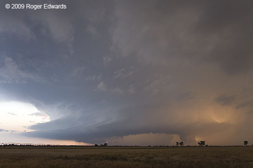
The Storminator
Contrary to my earlier hypothesis, Storm 1 (the old PUB supercell) took over and gradually absorbed Storm 2, turning in an absolutely jaw-dropping, prolonged display of structural delights, beginning near Las Animas soon after the merger. The combined storm, which mostly was the original Storm 1, liberally festooned itself with bands, striations, differential light effects, and occasional strongly rotating wall clouds wrapping up on its N side. These wall clouds quickly would get enshrouded in precip-filled occlusions downdraft cuts that coiled completely around their front (E and NE) sides, as viewed from the ENE on Highway 50 between Ft. Lyon and Hasty.
All the while, we blasted through one memory card after another shooting the amazing visual show at wide angles, sometimes zooming into another short-lived but rotating wall cloud. For a short time, the N side of what now was the only remaining storm (Storm 1) lit golden and orange in the setting sun W of LAA, while a very low-hanging and rotating wall cloud dangled beneath the N side of the spiralling pinwheel of supercellular glory.
Finishing up in Lamar: No Rats or Roaches
We let the storm go at LAA due to darkness, grabbed a $44 (incl. tax) room that (unlike the field project’s nearby accommodations) did not have spiders, roaches and mice. We then had a nice dinner at a restaurant in LAA. The place was about to close as we walked in…but stayed open at my request to feed a large number of arriving chasers after hours — including people pulling up from Bill Reid’s and Charles Edwards’ tour groups, a V.O.R.T.EX.-2 stereo-videography subgroup led by Jim LaDue, and us. It was good to see Dave Lewison and Rocky again, along with photographer extraordinaire Brian Morganti.
We also saw Mikes Foster and Coniglio there. They, as well as Mr. LaDue, let me know that the project had gone down to Canadian before doubling back, confirming my earlier suspicions. Boy, did V2 ever put in a long day. Several of them saw us turning N out of LBL as they headed SE, and perhaps wondered what the hell we were thinking. 😀
What a fantastic and rewarding chase. It was the second day in a row of gorgeous, sculpted storms out of two days so far on the High Plains. This is why we love to be up there, west of 100W. If the season ended then, we would have been content, but in the end, we were very glad it didn’t!