
Beauty of Outflow Dominance
Nebraska Panhandle Bow Echo and NE Colorado Dry Downburst
16 June 11

SHORT: Fun day. Began in Hot Springs SD. Observed/photographed spectacular outflow-cloud structures (shelves, bands, stripes) with raging bow echo/haboob from BFF to N of SNY. Dropped S for peculiar, photogenic dust storm and sustained damaging gusts beneath high-based N rim of eastern CO MCS.
LONG: Back onto our storm-observing trek after a couple of amazing days in the Black Hills, flow aloft and at least marginal low-level moisture were beginning to juxtapose favorably once again to our south. We targeted the nearby Nebraska Panhandle for the prospect of high-based storms rolling east out of the higher terrain of eastern Wyoming. Browsing the morning maps, I was confident in upslope flow into that orography, along with afternoon storm initiation…but would there be too much, too soon, before the richer moisture could arrive in the evening? This scenario would mean outflow dominance.
Still, a conditional triple-point play in south-central KS was much too far away; and the mountains ain’t going anywhere. Blow increasingly moist air into them for enough time during daytime heating, and storms will form. Our goal: be downshear and see what evolves. High dew-point depressions portend shelf clouds, dust and high wind from storms; and sometimes that can be beautiful too.
And so it was…
We drove to favorite overlook SW of Angora upon which we had perched a few days before, watching the top 4/5 of assorted towers build and glaciate over the unseen mountains of eastern WY. Finally, when the storms started to coalesce and move off, one of which looked like an embedded supercell on radar, we headed W to the N edge of BFF to watch them roll downhill right at us. By then, the supercell was hard to distinguish in the onrushing wall of a dark, ominous, and increasingly well-defined squall line.
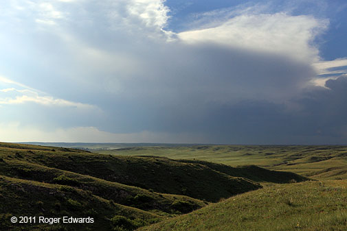
Reflectivity animations confirmed that the northern segment — basically due W of us, was bowing out. It was time to go outflow surfin’! Stay ahead of these, and they can offer some absolutely stunning cloud structures, such as the following three-piece view from between BFF and Minatare:
Looking NW: I’ve never seen a combination of lightness, darkness and radiating cirriform streamers like this before!
Looking W: Right into the teeth of Jaws. This is what a bonafide bow echo looks like when it’s “a-comin’ ta gitcha”. Check out the peculiar translucent strands, reminiscent of Silly String, festooning the otherwise featureless midlevel cloud deck. It might seem hard to photograph the strong dynamic range between the ink-dark core and the otherworldly apron of light above and beyond the shelf cloud; but not this time. This is how it actually looked, with no HDR bracketing necessary! I just had to meter for the area smack in the middle.
Looking SW: A classic view of an onrushing convective windstorm on the High Plains, this time with the Wildcat Hills lining the southwestern horizon.
We stayed ahead of the snapping maw of this storm — barely at time, I must admit — all the way to Bridgeport and beyond — before bailing S to let the road-deprived Sandhills have their turn at it. We got one last nice view of the atmospheric earth-mover raging to our NW before turning equatorward. What a gorgeous display of outflow-driven stormscapes we had witnessed!
Now it was time to get out of the way and figure out what to do with several more hours of daylight. Some storms had fired in NE CO, likely to be just as outflow-dominant and perhaps quite high-based. From SNY, it wasn’t that far away, and the next two days looked like potential Colorado storm targets anyway. As such, went back through Sterling again (retracing a good deal of our chase path from BFF three days before).
Unlike then, the Centennial State sky greeted us with a giant field of decaying storm material — virga dropping from various patches of agitation beneath a widespread anvil shield that once contained actual updrafts. N of Otis, a wall of wind slammed us in an impressive dry downburst, tearing dense channels of dust from plowed fields, buffeting the vehicle laterally with shot after shot of very localized wind-force lasting a second or so apiece, and making me struggle with the wheels to maintain positioning on the road. Good thing I had new tires for this season…
After a late rainbow and dinner at a familiar restaurant in Yuma, we bunked down there for the night, satisfied that we made the most out of a very windy storm day.
The human element of storm observing always has some interesting twists and turns too. We had a few loud neighbors at our motel, getting drunk and cussing in Spanish, and after a spell, I thought I might have to go out there and shut them up by request or otherwise. Fortunately for everybody, the former worked. The ringleader turned out to be cut from the cloth of my old barrio associates from long ago: he was wearing a shirt that said, in Spanish, “Don’t f___ with the DALLAS COWBOYS”. All day, I already had on my trusty blue-star cap. After some conversation about America’s Team, they retreated to their rooms, an elevated storm blew by with an intermittent show of close CGs, then off to bed everybody went.
A Championship Day (Even if Not for Storms)
High-based Storms in the Nebraska Panhandle
12 June 11
SHORT: From LBL, headed to the BFF area for high-based upslope action. Observed a few such storms from between BFF-AIA.
LONG:
The day wasn’t too spectacular convectively, but we saw storms and had a great time nonetheless.
Morning dawned to the analytic display of foci that were somewhere between muddy, nebulous and vague on the spectrum of precision. The surface map showed that the isodrosothermal field had been mangled by overnight and morning convection over southern Kansas, east of where we spent the night. When all else fails, the terrain just isn’t going anywhere–at least not for the next 20-30 million years or so.
We therefore headed toward the reachable area of the NEb Panhandle/NE CO, figuring that 50s F dew points in that area sometimes do good things as long as deep-layer shear is at least marginal. It also put us in position for day-2. Plus, Elke and I love that area for many nonconvective reasons.
After visiting an abandoned shack in western KS, we found a nice hilltop vantage about 5 SW Angora NEb, listening to assorted birds and photographing wildflowers (e.g., copper mallow, western wallflower, and veiny dock), as we waited for convective eruptions.
Assorted towers and turrets soon bubbled up to the W and SW. One persistent pile to our W evolved into a short-lived, high-based storm with a wall cloud to our NW, viewed across the rippled orographic musculature of the Nebraska Panhandle’s ash-bed grasslands. The storm exhibited weak cyclonic shear in the midlevels based on radar velocity output, but just for a few scans.
Other, smaller, junkier cells fired along the foothills in SE WY and over the western reaches of the Wildcat Hills to our SW, amounting to little except as a scenic diversion for aviators. We saw several contrails weaving between storms, including this scene over Minatare. The storms died off with the setting sun.
We settled into a charming little mom-n-pop motel in BFF with funky walls made of green quartzite from Utah. This also was the memorable night my hometown Dallas Mavericks won the NBA championship too–making up for a disappointing evening 5 years before in GCK when I watched them lose it to the very same team.
A very fine day, indeed…