
Tornadoes, Terrible Traffic and Thunderous Treasure
Loyal/Dover and Prague OK Tornadic Supercells
19 May 10
SHORT: After considerable waffling, targeted the eventual Loyal/Dover HP supercell and saw a couple of tornadoes. Got stuck in the epic traffic jam and left the storm in frustration. Intercepted a photogenic supercell in relative peace and quiet around sunset, near Prague.
LONG:
The Two Chumps, followed by Jack Beven in his rental car, left our lodging in Pampa around 1100 CDT with the notion of intercepting a supercell either along the outflow boundary from the previous night’s convection over central-northern OK, or if it could move into the better moisture and surface winds soon enough, any storm that formed near the dryline/outflow intersection near the OK border with the TX Panhandle. We drove to “Severe” Weatherford, watching the outflow boundary pass overhead and to our N with a gradually deepening and sharpening field of Cu and towering Cu along it and to its S.
A storm fired earlier than expected and farther W, back in relatively dry air with veered warm-sector winds near the border. This wasn’t too appealing to us at this point, so we waited for a spell for closer development near the boundary. We eventually wandered N, catching back up to the boundary as the original storm moved alng the boundary toward us in a rather awkward road network bracketing the Canadian River. Meanwhile, we could see the first deep towers of what would become the Hennessey storm going up 20-30 miles to our NE.
Now what? Faced with this choice, we were mired in an uncharacteristically protracted episode of indecision. Parked NE of Thomas, we sat about equidistant between the older western storm and the newer eastern one, both somewhat in view. We observed the sky, evaluated convective trends and surface data on our Internet connection, and photographed a wonderful little abandoned pumphouse and windmill.
Weather-wise, we just couldn’t decide between one option and the other, hoping for something to erupt in the “best” environment right overhead, even as both storms steadily matured into robust supercells — the eastern one in what seemed to be a better short-term environment, the western likely to struggle some but eventually move into a favorable regime for longer. The vacillation continued in our heads and in our travels for a long time, until the atmosphere forced our hand. Meanwhile we decided to wander NW toward Oakwood, a little closer to the tornado-warned western supercell, but keeping the eastern one in reach. Somewhere in our zigzagging of rural roads in the area, we lost Jack, though he did end up intercepting the western storm independently not far from us.
Meanwhile, we hit a dense deck of stratus and even fog, the temperature outside dropping into the 60s. The air N of this boundary was too cold and stable! S of the boundary, large dew-point depressions prevailed, a recipe for cold outflow development. Furthermore, by the time we got back S of the cold air again, our first view of the storm to the W across the river valley revealed a big but “cold” looking base with towers erupting over the top of what appeared to be a partly modified cold pool. The storm also was accelerating. Bad news!
We decided to get through Watonga and make a dash for the storm approaching Hennessey. Alas, it too accelerated, but away from us, tornado warnings and even reports starting to stream in over the TV simulcast on our vehicle radio. Damn, we thought…would we miss the show today? Glances back at the western storm indicated less stratified and more unstable structure, and it was moving toward the area just to our N.
Our decision had been made for us, so we ended the waffling and headed N past Omega to get in the western storm’s path again. As we headed N toward the optimal easterly escape position on the familiar E-W road through Loyal (a venue for tornado success on 4 October 1998), the supercell churned east toward us at disturbing speed, revealing itself as an HP “Stormzilla”.
It was assuring that we had a dependable east road, at least until it stopped at a T-intersection WSW of Dover, when where knew we would have to dive S. With an uncomfortably zesty component of forward-propagation, we couldn’t stay in any one spot long to observe and photograph the beast. The only realistic chance to see any tornadoes it would produce would be from about our latitude, E to ENE of the HP mesocyclone and NE of the onrushing drum of heavy rain and hail.
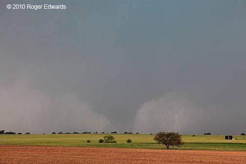
Sure enough, as we stopped alongside Bobby Prentice and Gene Rhoden 1 mile E of Loyal, a small but unmistakable tornado formed in the rain to a few miles our W. In a Keystone Kops moment, fumbling around for a zoom lens in a new photographic vest that I unknowingly wore inside-out and backward, I missed capturing the best ground contact of condensation, shortly after this shot at 1734. Fortunately Rich had just one lens with which to fumble, and snapped a shot at the right time. The irony was that my 200 mm zoom lens (for the only time ever) couldn’t reconcile itself with the camera, and the viewfinder settings somehow didn’t match what actually was shooting — by 3 stops or more! I hadn’t experienced this before, nor with numerous shots using the same lens since. Go figure. The zooms were underexposed crap, and I quickly reattached the 24-70 mm L-series glass.
By that time (1736), the tornado was vanishing in a major mesocyclonic wrap-up of rapidly rotating clouds and precip, and we had to go back E to stay ahead of the surge. As we headed S, 4 SW of Dover, we peered into the gorgeously turquoise-capped murk of rotating HP mess a few miles to our WSW and spotted another tornado. As we ran up an embankment to shoot, the curtains parted to reveal a fat cone with multiple vortices whipping around its base (time 1751, estimated tornado location 4 SE of Oneida). This was an eerie and beautiful sight, but with the mesocyclone now right-moving toward the ESE and us needing to get out of its way, we knew we couldn’t sit there sipping mango Slurpees and listening to Jimmy Buffett songs. A few more shots, including this wide-angle (can you spot the tornado?), and it was time to bail S.
Unfortunately, we took a little too long and got stuck behind a local lady whom we couldn’t safely pass, driving 40-50 mph in her pickup. She didn’t seem to grasp the urgency of the situation. We also inaccurately assessed the distance of the rain-wrapped tornado and the speed of translational motion, such that when we drove S through the E side of the precip, the tornado’s bottom unexpectedly appeared as a ferociously spinning cage of precip and condensation in the field about 300 yards to our W. Not cool. Rich was able to peer up at the funnel heading our way at a barely beatable pace. Fortunately, he gave a blow-by-blow update of its position as we scooted out of the way, letting the vortex cross the road just behind us. This was a definite misjudgment on our part, which certainly didn’t help our mood in what was about to take place.
Relieved to get out of that whirling cauldron, we headed E on a paved road 3 N of Kingfisher in order to get ahead of the storm while avoiding the traffic delays of the town, stopping quickly to look back at the deeply rain-wrapped supercell now off to our NW. Turning S to go to OK-33, we suddenly found ourselves one amongst many, many vehicles in a miles-long strand of brake lights and antennae, extending over the next hill, the one after, the one after, and the visible horizon.
I’m not talking about tens, or dozens, but hundreds, perhaps thousands of vehicles. Yes, we were part of the problem — if there were 2,000 cars, we were 1/2000 of the horde. I’ve got extensive experience on the streets and freeways of Dallas and Miami, and have seen the worst that their traffic snarls have to offer. After this, I rather would sit for four hours on a hot day in the parking lot of Central Expressway or Florida-836 than endure what happened on OK-33 again. Even with the great majority of these near-storm watchers behaving themselves, this was the most intensely stressful driving situation I’ve ever been involved with. Imagine mile after mile of vehicles in a long train on two-lane country roads, all moving at the speed of the slowest (around 40-45 mph on average) with a certifiably tornadic HP supercell bearing down hard. We already had been involved with one close call of our own doing, and wanted no part of another caused by a traffic jam.
At one point, while waiting behind a 30-40 vehicle line to turn left at a stop sign (onto OK-33, which also was jam-packed), a chase-yahoo behind us pulled into the left (oncoming) lane, raced past the line of cars up to the corner, ran the stop sign, drove in the oncoming (westbound) lane of OK-33, then jammed himself into a gap in that traffic about a quarter mile E of the intersection. This person thinks his life and car are more important than everybody else’s, and needs to be taught otherwise. [Only later did we find out about some wantonly dangerous behavior earlier in the afternoon by a separate “team” of chasers affiliated with a Discovery Channel production.] Yes, I was and remain angry about this. No TV footage or storm video is worth endangering innocent lives! Somewhere in hell I hope there’s a special slow-roasting pit set aside for selfish little cowards like that, and all who share such a mentality.
Even though all others we saw in the huge traffic jam were more civilized, we were absolutely and completely at the mercy of the everyone else out there, and it was time to bail out of this asphyxiating and dangerous crowd. At one point near Guthrie, we caught a glimpse of the circulation that produced the last visible funnel with that storm, but we had enough of the circus and headed S on OK-74 and away from the supercell. It’s the first time I’ve ever left a tornadic supercell, on purpose, because of the presence of too many other people.
Initially hoping to get ahead of the messy supercell headed for areas just S of Norman, we headed E on the Kilpatrick and Turner Turnpikes, gaining great time, then S on 177. Instead, we slowed down a little to let a small but tornado-warned storm pass across the road to our S, then drove down through Jacktown, right behind the back edge of this most interesting supercell located between Meeker and Aydelotte. Through thin veils of precip wrapping around the NW side of its hook, we easily could see its rotating wall cloud to the SE. This was an unusual vantage of the business end of a supercell, given both the direction of view, and the dense crosstimbers that characterize most of the area E of OKC. Conveniently, a crew with the local fire department and county emergency management pulled up, so I explained to them what was going on, they radioed the news up the chain, and we watched the mesocyclone pull NEward to our SE and E for a spell.
Meanwhile, the clouds to our W opened just for a minute, casting a dazzling portal of late-afternoon sunlight over the landscape and a brilliant rainbow across the supercell to our E, still sporting a visibly rotating wall cloud through translucent precip curtains. This wide-angle view, pretty as it is, doesn’t do the scene justice. In the distance, below and behind the wall cloud, behold the CB for another tornado-warned supercell, located over far eastern Oklahoma. In the face of this kinds of atmospheric grandeur and beauty, all my tension from earlier simply wafted off on the rain-cooled breezes. It was as if another chase day was born, and a fresh opportunity for immersion in amazement of natural wonder had been set on our table.
Newly energized for one final intercept run of the day, we headed S and I on I-40, stopping for a piss break and an occasional look at the sculpted storm to our N in the fading daylight. An obvious mesocyclone with several suspicious lowerings appeared, then cut a pronounced clear slot while apparently consolidating its area of storm-scale rotation. This may have been the tornado reported 6 W of Prague at 2015 ( enhanced crop-n-zoom), especially if the report time was 4 minutes late (shot at 2011). It was in the right part of the storm — a matured occlusion area — and its apparent position, relative to ours at the time, matches the location of the report well.
That mesocyclone weakened and a precip surge to its NE obscured the new mesocyclone with more HP character. We watched it pass to our N from the North Canadian River bridge area on US-377, then returned to Norman, tired and spent, and ready for rest after one of the strangest and most draining chase days ever.
You Decide
Dumas-Stinnett TX Supercell and Tornadoes, 18 May 10

SHORT: Witnessed intermittently tornadic supercell (specific tornado count uncertain) from NW of Channing TX to NE of Stinnett before losing it to darkness and a road void.
LONG:
Rich Thompson and I (the Two Chumps) headed out of Norman with modest expectations for a dryline supercell chase day in the Texas Panhandle, given the “recycled” nature of the moisture (dew points in the 50s to near 60, left behind by prior convection over Oklahoma, though enticing levels of shear helped me to convince Rich that it was worthwhile to head west. Jack Beven linked up with is at Battlestar Norman for the trek out, following us in his rental car.
The storm of this day would exceed expectations, frustrate us, fascinate us, play hide-and-seek games with us, and flabbergast us in many ways, and overall, definitely was worth the trouble! You’ll soon understand why my efforts at photographic forensics has taken so long since, and why I’ll shamelessly borrow Fox News’ favorite slogan for some of the strange and mysterious phenomena we witnessed.
Our general target area was DHT, where we hung about a bit, and where several runs of the short-fuse HRRR had predicted a locus for 2-3 dominant late-afternoon supercells over the western and northern Panhandle. Foci for convective initiation seemed rather nebulous, except for the diffuse dryline far W of us near the NM mountains, and a confluence line with some cumuliform cloud enhancement to our near S.
Once some high clouds thinned enough over the confluence line, towers deepened rapidly, and the first storm of the day erupted merely 25-30 miles to our SSW. This seemed too easy — a rapidly intensifying storm in our general forecast area of the NW TX Panhandle.
We charted an intercept course between Hartley and Channing, and soon had a nice view of the young tempest’s already supercellular appearance (looking W from ~6 N Channing at 1658 CDT). Nearly continuous rumbles of thunder high up in the anvil and vault regions signaled essentially continuous zips of lightning, indicating an active ice-particle charge separation region and, along with its clearly supercellular inclinations, active generation of even bigger ice particles (namely damaging hail) aloft. This storm’s inner forward flank absorbed a growing cell originally to its S, and seemed fortified instead of handicapped by the encounter. It clearly wasn’t fooling around.
Content to let the storm churn along slowly toward us, and across the dissected scablands of the Canadian Breaks, we observed a few obvious (albeit scuddy) wall clouds and mesocyclonic occlusions, each with more sustained and well-defined low-level rotation than the previous. In this example (looking NW at 1722), behold the scuddy wall cloud at distant left, which was rotating with a well-developed clear slot cutting in front, while a newer, flatter, larger base and wall cloud formed at nearer right. The right circulation would become the dark, menacing photo you’ll see later (Dumas mesocyclone), while the one at left would persist for many miles and minutes, and yield our first unambiguous tornado.
By the time the newer mesocirculation passed US-385 just to our N and headed toward Dumas, we were ready to maneuver that way, when the older, more deeply occluded one tightened up rapidly, and began spinning like crazy. Cloud condensation reached most of the way groundward with and a funky little tail cloud at rear and dark shards of scud in the foreground for added spooky effect [looking NNW from 7 N Channing at 1734). Between that shot and this one, at 1735, a brief dust spinup occurred beneath, indicating the first tornado of the day (albeit cheesy). The low-level circulation crossed the road to our NNW without obvious dust or debris, then got partially rain-wrapped to our N and NNE. From within the murk appeared a very obvious, low-hanging condensation funnel with intermittent wisps of dust and condensation spinning at ground level beneath. Time of this undisputed tornado stage was 1744. Was this a second, separate tornado or an extension of the earlier one, the interval merely being too weak to be visually manifest? We report, you decide.
Atmospheric vortices aren’t always clean-cut, nor are they easily segregated from one another in tight, cleanly demarcated spectral bins. If the head-scratching already underway on weren’t enough, the remnant circulation moved farther ENE, away from us, wrapping in more rain, without obvious debris or condensation. Then…
What in the hell was this? Check out the enhanced version. Location of the feature was about 9 NNE of Channing, time 1749, still in that old meso that wouldn’t die. The scuddy, fat cone was rotating (not very fast); and instead of spinning up debris, was hoisting condensation off what looked like the SW edge of a bank of hail fog! Tornado or not? We report, you decide.
Tornado #1, (or was it 1.5 or 2 or 2.5 or 3?) duly documented, we bailed E along FM 722 to regain position abeam of the eastern (younger) mesocyclone. Stopping near Middlewell, we did just that, but found also a low-hanging pillar of condensation that intermittently extended to the ground from the old circulation, now to our NW (time 1757, see enhanced version). Another tornado? The same one? None at all? We report, you decide.
Finally, that area began to lose definition, and the separate, very obvious, big, intense, strongly rotating and probably tornadic eastern mesocyclone matured to our N (and about 7 WSW Dumas). Here’s an enhanced crop-n-zoom. It surely looks like there’s a condensation pillar in there, planted on the ground. Real or Memorex? We report, you decide.
The area of strong rotation began to fill in some with what looked like rain-wrapping condensation, toward the already well-warned burg of Dumas. We tried to get through and E of town before it did, but upon penetrating the starboard rim of the bear’s cage on the S side of town, wisely decided otherwise, and bailed back S. A tornado was reported in Dumas, though little damage was done (according to later reports). We had to go all the way down to Four Way, E to Lake Meredith and N on FM 1913 to TX-152, removed from good view of the storm’s rotational underbelly until this striking wide-angle scene 19 miles E of Dumas.
We headed a mile W and another half mile N on FM-1060 and let the storm, which had begun to accelerate eastward, move almost directly toward us. Meanwhile, dozens upon dozens of chase vehicles materialized on the roads all around, including what appeared to be the full V.O.R.T.EX.-2 fleet. Fortunately, unlike the next day, everyone we saw was well-behaved and the traffic did not impede either safe viewing or, when necessary, safe escape.
As we waited, a broad, ragged but very strong area of rotation cranked up at cloud base, a skirt of lowered cloud material orbiting the boundary-layer mesocirculation center at eye-popping speed, the inflow at our backs rapidly evolving from stiff breeze to assuredly severe levels. This transformation was amazing. We struggled to stand upright, my vehicle rocking in roaring inflow winds that whistled and jostled power lines overhead. The storm was doing what Erik Rasmussen once termed the “big suck,” a frequent harbinger of imminent tornadogenesis. We were confident it was about to plant the “big one” any minute.
Instead, it teased us with a small one, and not in the main merry-go-round either. At 1911, a funnel appeared under the rear (NW)-side tail cloud, at center in this 70-mm wide angle, a faint column sheathed near ground by dust and/or precip evident beneath in this enhanced crop-n-zoom. That “cheesenado” moved S and vanished quickly behind the increasingly precip-filled, spinning carnival ride of rain curtains and dust daubs orbiting the main circulation.
The blasting inflow winds subsided only when the rear-flank gust front approached our location, so we headed E on 152 toward Stinnett. Along the way, another faint but unmistakable dirt daub appeared near the leading edge, in the distant NNW, lasting 2-3 minutes. Look beyond the third fencepost from the left in this shot. It probably was just a gustnado, but at this point, who knew? How many tornadoes had we seen? You decide. By now we were certain only in our uncertainty. It would get no easier!
A more intensely rain-wrapped and turquoise hue fell over the storm scene as we stopped to view the storm from both a scenic overlook W of Stinnett and from TX-136 N of Stinnett. Flaunting a flash of comic cruelty, almost exactly between those shots, and as we were passing through town with no good view of the main mesocyclone area, the storm produced a visible cone funnel and brief tornado that some other observers saw from N of town.
Parked about 3 N Stinnett, a gigantic road void preventing the storm from being followed farther E, we let the main mesocyclone pass to our N and NE, hoping for a view into the circulating pillars of rain and hail from the SW or W. Meanwhile, as the rear-flank region passed over, a thin, snake-like funnel contorted itself in the turbulent, non-mesocyclonic cloud base less than a quarter mile to our W. Rich was on the passenger (E) side and didn’t see this, but I did alert him. Dying as it moved overhead, I felt as if it posed no appreciable danger, though Charles Edwards (who was to our S) drove up a few minutes later to let us know that he had seen the flanking-line funnel over us too, and was somewhat concerned for our welfare. It struck me as, at worst, a “Weaver walk-through”. A brief shot of hail up to 1.25 inch diameter passed across us also, visible in this shot as bridal veils of hailshafts cascading into the fields to our immediate SE.
Meanwhile, something very suspicious appeared behind the precip curtains, and in the area of rapid mesocyclonic rotation a few miles to our NE. What was that? Some nearby observers swore it was a rain-wrapped, multi-vortex tornado, and maybe it was. Here’s the enhanced version. Time was 2001.
We report…
As the whole area retreated off into the roadless prairie wilderness of the Canadian River valley, a more well-defined wall cloud appeared behind the precip (enhanced image), perhaps with some spinups beneath.
…You decide.
Whatever happens NE of Stinnett stays NE of Stinnett. 🙂 Actually, that’s not far from reality. That area is a vast, roadless tract of grass and scrub, on which even an aerial survey might not help forensically except for the most violent of tornadoes. We may never know for sure what was happening inside that furiously rotating cascade of hail and rain.
As we prepared to head S through Stinnett to find lodging in Pampa, we noticed that another, more ragged storm to our W had begun to rotate visibly at cloud base. It obviously was drawing in just enough unstable air for survival, from above or S of the shallow outflow boundary left by the big departing supercell. As the shrinking circulation passed to our N, with a ragged wall cloud, we did experience brief retreat of the boundary last us, and warm and moist S winds. This area merged with the W side of the bigger storm in that void, and in increasing darkness, while we high-tailed it to food and motel in Pampa.
Though pleased with our chase overall, and satisfied that this day did more than we expected with “recycled” moisture, we lamented that we could muster nothing more than brief spin-ups that were hard to see, and how on earth we ever could get a photogenic tornado to fill the camera lenses. Alas, thanks to family matters and work obligations, we were unable to chase on the days later in May, in SD and in the SE corner of CO, that provided many other storm observers with some of the most strikingly picturesque tornadoes documented this decade. Still, it was nearly cathartic to get out on the wide-open High Plains again, and a far bit less stressful than the unprecedented and dangerous circus of storm-viewing traffic that would dog us in OK the next day.
Daytime Mild, Evening Wild
Hennessey to Anadarko and Norman
13 May 9

SHORT: Observed multicells and supercells before dark from W of Hennessey to SW of Calumet. Witnessed Gracemont-Anadarko night supercell and power flashes from tornado and RFD winds. Observed part of separate supercell E of Norman after earlier tornado.
LONG: Given the very strong capping that was forecast, and the increasing uncertainty of diurnal storm initiation with southward extent, Elke and I targeted a conceptual zone just NE of the projected “anchor area” of a front-dryline intersection zone. The plan was to grab storms discretely backbuilding SW down the front and watch them in stair-step fashion, until either they lined out or became less interesting than newer development. Once, again, confidence in cap strength gave us the luxury of a late lunch in Norman, before we headed up to Kingfisher. Storms fired to our NNE near the KS border (one of them being the briefly tornadic event that Joel and Blufie captured on the way W from TUL…great work, dudes!). We briefly considered that activity, but turned our attention to newer cells visibly erupting into the sky over Major County, NW of town.
When we arrived at a decent viewing spot between Hennessey and Okeene, the bases looked rather flat and linear, as if frontally forced; but the then-anchor storm got better organized, with a nice anvil push with mammatus, and some tail cloud development off the NE side. ESE storm movement and CGs chased us from the spot. We headed S — coincidentally on the same paved back road W and SW of Hennessey from which we photographed a spectacularly unplanned “planned burn” earlier this season. Other smaller cells started to develop farther SW, merging into the complex, and contributing to a hard net right turn and SSE motion that had us zig-zagging on some paved, but at times quite rough, unmarked roads from Kingfisher SW to Calumet, keeping within viewing distance of the storms now pounding areas around Watonga and Geary.
The daylight was getting short and the low-level jet began to crank up, so we had some hope for more convincing supercellular structure. After exiting Calumet, those hopes came to fruition. On the NE side of the newer cluster of storms to our W (the same one under which Kiel O and KMan observed the landspout up close), a bonafide supercell formed and quickly developed a very low-hanging, slowly rotating wall cloud (wide angle and zoom).
We headed over I-40 S of Calumet, faced with either a 32-mile detour E, S then W on good roads, but with little daylight left, or 4 miles of thinly graveled dirt road leading to to an unmarked paved byway headed S toward Cogar with a bridge over the Canadian River. I chose the latter; and the “crappy” road actually was friendlier to my car than the many more miles of paved but horrendously maintained trash we had been traversing between Loyal and Calumet.
Meanwhile, the wall cloud had gotten undercut, but the broader storm began to acquire striations, and assumed a more circular appearance. In the fading twilight, we could make out a more sharply banded, “stacked plates” appearance to the storm while rounding the corner from Cogar to Gracemont, staying just ahead of its hard southward charge.
Here comes some meteorological discussion for the unitiated to skip, if compelled. I figured this laminarity was related to the balance between the storm’s improving organization and the strengthening of both capping and environmental low-level shear. A mixed-layer lifted sounding curve was “capped” in a pure parcel theory sense, and growing more so all the time through gradual diabatic cooling of the near-surface layer. Despite that apparent handicap, the supercell’s strengthening deep mesocyclone and vertical pressure gradient force caused deep ascent of parcels from the boundary layer through the environmental capping inversion. Effective lifted parcels still were bringing near-70 degree dew point air from the surface into this storm, while the LCL was lowering due to cooling temperatures and loss of deep boundary layer mixing. The strong inversion also was keeping the storm cluster rather isolated from a few others farther NE along the front, so it had no “outside competition” or impediment whatsoever for high theta-e source parcels, other than being able to maintain its own inflow-outflow balance. Storm-relative inflow was quite favorable, thanks to the supercell’s deviant SSE to S motion right into the intensifying low-level jet, which also was enlarging the 0-1 KM AGL hodograph and storm-relative helicity quite a bit. As long as the storm could forcibly inhale surface-based air in this window of opportunity (before either losing access to the boundary layer or evolving into a bow echo), it could survive, thrive and perhaps get really dangerous.
OK, that was the end of most of the jargon…
I described all that because it seems to fit a pattern we often see precede tornadoes with very late afternoon supercells that seem rather unproductive by day, then go berserk at or just after dusk. This one did!
I tried to find a vantage between Gracemont and Anadarko to watch the storm coming in from the N. It’s a good thing we didn’t succeed. Instead we turned E out of Anadarko toward a favorite viewing spot of mine — a service driveway for a hilltop broadcast mast located exactly 6 miles E of town, off the N side of Highway 9.
We parked on the big signal hill watching and photographing that (by then) spectacularly sculpted supercell move in, illuminated by lightning. While we were still parked but packing up, and right before the power flashes started, Elke saw some sort of conical downward protuberance to the near right (N) of the eventual location of the flashes, to our W, silhouetted by faint lightning flashes.
Unfortunately, my still camera had been pointed 90 degrees the other way, northward toward that great structure on the storm’s E side and occasional CGs blasting through the vault region. The last shot was three minutes before the Gracemont-Anadarko tornado became indirectly apparent to the W, off the left side of the image.
We had to bail due to encroaching CG activity (that was my widest wide-angle!); otherwise I might have had a photo of a night tornado — or at least, wheeled the tripod head around for to capture its effect of snapping utility lines. As we were pulling out of our parking place, we saw around a dozen bright power flashes in several different spots ~6 miles to the W, within a 3 minute span…in or very near the N side of Anadarko. The flashes appeared to be buried in thick precip, but were quite vivid, displaying a variety of coloration — some blue, some green, some in between, even a couple with reddish and yellow tinges.
Unfortunately, damage obviously was occurring, but we failed in our attempts to report it in real time. Elke wasn’t getting any traffic on her pre-programmed HAM frequencies. [Turns out the net control operator was sustaining damage to his own business there in Anadarko.] I tried to call the 1-800 numbers I had for the WFO but instead got either a recorded message asking me to call a different 1-800 number to “chat with friends nationwide” (for one number) or rapid busy signals (for the other). [I’ve since gotten updated contact info…thanks Rick for responding so fast!] We then lost all cell signals until we got to the S side of Chickasha, which is very unusual. Finally, somewhere S of CHK on US-81, I was able to call work and ask them to relay the delayed report of the power flashes to the WFO.
We then heard the tornado warnings close to home in Cleveland County, abandoned our (by now) outflow-dominant HP monster SW of Chickasha, and made a beeline back to Norman. We arrived after its weak tornado near Stanley Draper Lake. From Highway 9 east, not far from our house (!), we saw a ragged wall cloud moving SE across the Lake Thunderbird area before it got lost in precip and distance. The lightning show on the back side of the supercell’s HP hook was continuous and dazzling, but mainly in-core. I did capture a few CGs (like this one) looking out my east facing, second-floor window at home.
Based on WFO Norman’s damage survey the next day, an RFD caused most of the damage in Anadarko; but a significant (EF-2) tornado did track from Gracemont southward into parts of Anadarko. This probably was the conical lowering Elke saw right before the power flashes. Here was that part of the WFO report:
-
TORNADO – CADDO COUNTY – NEAR GRACEMONT TO ANADARKO
922PM-940PM
THIS TORNADO LIKELY DEVELOPED NEAR GRACEMONT AND MOVED SOUTH ALONG
AND JUST EAST OF HIGHWAY 8. THE MOST SIGNIFICANT DAMAGE WAS NOTED
ALONG COUNTRY CLUB ROAD IN ANADARKO WHERE SEVERAL HOMES HAD
SIGNIFICANT DAMAGE. THE PRELIMINARY RATING FOR THIS TORNADO IS
EF2…ALTHOUGH THIS IS SUBJECT TO CHANGE PENDING FURTHER REVIEW OF
DATA. MOST OF THE DAMAGE IN ANADARKO WAS LIKELY THE RESULT OF
STRAIGHT LINE WINDS ASSOCIATED WITH A LARGE REAR FLANK DOWNDRAFT.
Since we were perpendicular to (east of) both the tornado and RFD tracks, I don’t know how many of the flashes were tornadic in origin, and how many were caused by RFD wind. The power flashes illuminated dense precip, and were rain-wrapped. It was sobering and sad to know that people were in danger, unable to communicate about it, and only hoping nobody would get killed or hurt seriously. I’m glad and pleasantly surprised that the Anadarko tornado/RFD damage event didn’t.