
The US-412 Supercell
Enid/Garber OK
8 Apr 11
SHORT: Modest, yet enjoyable supercell observed east of Enid that developed in the warm sector (not on the dryline).
LONG:
The initial thinking from prior days, and early on this one, was that a dryline storm could fire somewhere over western OK in a zone of intense heating and mixing that would overcome strong EML-based capping, and move eastward into more moist air for a short time amidst an ambient kinematic profile most definitely suitable for storm-scale rotation. Instead, we ended up with one warm-sector supercell out of several! Here’s how…
A persistent zone of northward-moving, gradually deepening cumuli, corresponding to a zone of intense heating and mixing east of the dryline, formed during early-mid afternoon over NW TX near Vernon, and also, in an area of weak surface wind-shift and mass convergence as evident in both plotted charts and objective analyses. This immediately caught our attention (Corey M, Rich T and I); and we began to ponder this as a potential storm genesis source. The later it went, the farther N it would go; as the combined surface and satellite feature was moving N across I-40 and into the Kingfisher area by the time we left. After Rich picked up his son from school; we all met at Battlestar Norman and departed for El Reno via the Highway 9/turnpike bypass, intending to head N on US-81 from El Reno.
While near the former Kelvin’s Corner, we spotted turkey towers with glaciation to the NW, a good sign of deep ascent that encouraged us onward. VIS imagery showed a boomerang-shaped field of deeply enhanced Cu, much of which we couldn’t see visually from a distance because of smoke-related boundary-layer haze. The inflection point of this boomerang was moving N from the Kingfisher area; so we headed that way. That’s where the first echo–the eventual Enid storm–erupted while we were approaching Kingfisher.
We cruised up to Hennessey as the nascent supercell grew, towers rolling up its near (SW) flank and backshearing. The storm lost some organization on radar during an initial storm split; but its updraft towers till looked robust visually. In accordance with that encouraging sign, the right-split recovered nicely from the initial body-blow as we maneuvered E on OK-51 and N on OK-74 toward Covington.
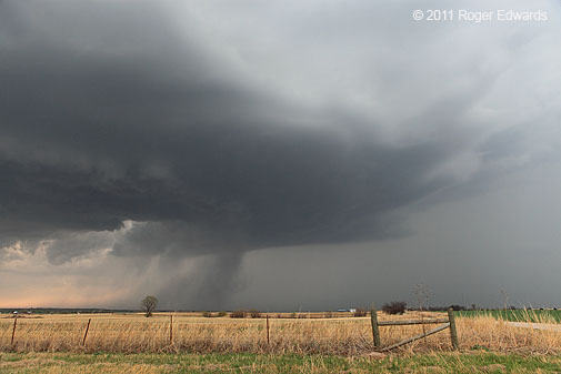
Our initial views of the underside from SW of Covington (no photos…stupidly, I left the camera in the back of Rich’s vehicle while we were driving) revealed a high, somewhat disorganized base. As we approached from the S, the eastern portion of the updraft region began re-ingesting a partial mix of rain-cooled air. Huge chunks of scud formed and rose, appending themselves together into a tall, ragged wall cloud that rotated slowly, assuming a triangular shape for a short time. At one point, the point of the triangle lowered about 4/5 to the ground from a very high ambient cloud base; but rotation was slow at best, and no dust or debris could be spotted beneath. This seemed to be the “almost a tornado” phase some chasers described.
As we reached 412 and turned E, the storm was in its best-organized phase–peak midlevel rotation in SRM displays and that ragged, occasionally low-hanging and pointed wall cloud with obvious cyclonic shear. The meso wasn’t strong enough to pull a great deal of precip around yet. As we continued E on 412 and got abeam of the circulation, a lot of the scud evaporated, as if the wall cloud were disrobing to reveal a peculiar, tilted but mostly horizontal cloud vortex. This feature narrowed into a skinny, nearly horizontal funnel, somewhat bent, and way above the ground. We didn’t deem this an imminent tornado threat.
By the time we pulled over at an optimum vantage, and I got out the camera, the laminar, horizontal, funnel-like feature to our N had vanished; and the ragged wall cloud was eroding away to reveal the more ambient, high base again. At this stage, the structure reminded me a bit of the 22 May 7 supercell near St. Peter, KS, but of course, without the tornado! Storm motion slowed down; and we were able to maintain a leisurely pace east on US-412 with a couple of long-lasting stops to observe the supercell’s high but well-structured underside to our N.
The storm attempted a couple of occlusions, including this one with a well-defined downdraft slot and precip cascade, while surface-based inflow still was screaming from the S and buffeting us reasonably well. Soon, however, the inflow calmed a bit, and the storm took on a more laminar, elevated appearance as it approached I-35 (shot looking NNE with CG from the vault region).
As the storm continued to weaken, we bid it a fond farewell, and headed S on I-35 toward home.
This was a fine first chase of the season, a good opportunity to work out some kinks, test new equipment, and re-learn needed lessons (i.e., “Self, you forgetful doofus, keep the damn camera in reach while someone else is driving!”). It was great to get out on the Plains again and watch a supercell–a cathartic release from the psychological imprisonment of a long, cold winter. Even though we are mired in deep drought here in central OK, we bear hopes for at least a few more photogenic supercells within reasonable driving distance the remainder of the season, as prospects for the big events already appear to be displaced far, far away.
2010 Chase Season Dénouement
22 Jun 2010
Southeast WY to North Platte NEb

SHORT: Outflow-dominant supercell observed twice — once in SE WY and another in NEb Panhandle. Gorgeous sunset supercell S of Paxton NEb.
LONG: We were hoping for one final photogenic supercell for our chase vacation, and instead got two.
A piping hot lunch at a local cafe in downtown Sidney NEb, featuring a platter of smashed and fried Rocky Mountain oysters, settled down hunger’s restlessness just long enough for us to watch satellite imagery on the mobile phone, seeking first signs of convective initiation on the Laramie Range to our W. This area would experience favorable upslope flow, decent low-level shear and deep-layer winds, along with sustained surface heating in the absence of any appreciable, antecedent cloud cover, but moisture seemed a tad on the scant side. Once the first towers started to fire NW of CYS, we hopped onto I-80 and roared westward.
By the time we got to Pine Bluffs WY, deep towers were visible with glaciation to our NW. We could see the cloud bases easily, so we fueled at a truck stop there as I chugged down a cold, delicious A&W float. I also reserved a room in LBF for the night using a combination of forecast storm motion and positioning needed to go back home the next day, while watching for a storm to congeal and organize from the agitated area. Soon, it did, and we took off W through Burns and then N, retracing in reverse a segment of our chase path from the tornadic Chugwater event two days prior.
True to the lack of more robust moisture, the bases seemed uncomfortably high, and I was troubled further by how fast the cells started moving E off the mountains as we approached. Was the convection already spewing outflow? Yes! We barely beat the storm to the intersection of WY-213 and WY-216 W of Albin, near which I shot this photo looking W. Yes, there were updraft bases all right, but they were being undercut very quickly by wickedly cold currents hurtling SE from the precip cores. We headed E on 216 to Albin, having to make a decision there either to:
-
1. Take unpaved back roads and stay closer to an outflow-surfing wind and ice machine, risking its outrunning us for good somewhere not far E of the WY-NEb border, or
2. Shoot back down to I-90 and bust eastward at higher legal speeds so we could stay abeam and eventually get back ahead of the storm on a north road.
Although I’ve seldom seen such an outflow-dominant storm recover to produce tornadoes, it has happened on one occasion. Furthermore, such storms can produce interesting and sometimes beautiful cloud formations, especially out on the high plains. The decision was easy.
Meanwhile, before zooming down to the Interstate, we watched the storm cross the road to our N, spying a suspicious-looking but very short-lived formation buried in a mesocyclonic notch region (enhanced crop-n-zoom of previous image). That feature quickly vanished, and the whole messy and wild-looking process roared past.
By the time we got just the few miles S to I-80, the storm already had gotten well off to the NE, brilliantly festooning a deep blue sky (wide-angle view from I-90 near the border), with a high and ragged base visible on the trailing flank. That, along with the main updraft base of the storm to our left, were visible as we cruised E to Sidney, then N toward Gurley — in the process retracing a late-day segment of our trek from the previous season’s intercept of the LaGrange WY supercell. For our nearly continuous view of the updraft while driving, and several chasers who were closer at that time and didn’t see any tornado, I had to question the “sheriffnado” reports just E of the border in NEb.
We got directly ahead of the storm again E of Gurley, watching its somewhat-lower base with a small, shallow wall cloud developing to our WNW (wide-angle view) while a deck of low clouds formed overhead. The storm itself was decelerating markedly, and its own outflow boundary appeared to outrun its main reflectivity area (and mesocyclone aloft). I got a dread that the supercell wouldn’t last much longer; and it certainly did not. A zoom view shows the wall cloud that was surrounded by translucent precip. Within minutes, a fuzzy gray bowl of precip appeared right in and under the wall cloud, descending and expanding and obliterating the wall cloud as it reached the ground, and making a splendid example of a tornado look-alike.
Was this a descending reflectivity core (DRC) that came down in a very deleterious place for any low-level mesocyclone’s development and survival? It sure seemed as such. Here’s the view 3 minutes later, when the precip core further expanded and utterly obliterated the cloud base where the wall cloud previously had dangled. Within 11 minutes more, the outflow had gone past, the low clouds cleared away to reveal an astonishingly rapid storm demise!
Thinking that was it for our chase season, we headed E toward LBF, only to see a stunning and spectacular convective eruption to our SE, S of Paxton, beneath a waxing gibbous moon and shortly before sunset. As this storm evolved into a short-lived supercell, we admired the amazing spectacle from a corn field a couple of miles S of the Interstate, until an inverse relationship between amount of sunlight and mosquitoes hastened our resumption of the trip. What a wonderful way to close out the last chase of Spring 2010!
When we settled into our room in LBF, the clerk remembered my call and said we were smart to do what we did many hours before; all the rooms in LBF were booked up solid! After 11 p.m., we noticed a dramatic increase in lightning to our N-W, as storms erupted along the outflow boundary. While cruising S of town in search of a good vantage in that direction, the storms weakened again, precluding any decent lightning photo opportunities, though we did salvage a nice look at lunar crepusculars around an altocumulus deck.
This was a rewarding day, one that left us in ideal geographic position to do something we had wanted for a long time: pick up a stone fencepost from one of the quarries near RSL. It would be right along the way home the following day. Our adventure in doing so was a marvelous glimpse of Americana, chronicled in more detail in this BLOG entry. The dénouement had been written on our chase season – one that was, at times, agonizingly frustrating, and at others, as fulfilling as can be. What adventures await in 2011?
Colorado Kick-start
Bennett and Limon/Genoa area supercells
11 Jun 10

SHORT: Outflow dominant supercell intercepted E of DIA airport, followed by cyclic complex of supercells from LIC to E of Genoa CO.
LONG:
The previous morning, I got off a night shift at 8 a.m., and Elke and I made a dash toward the NW to see how far we could get toward that day’s (and definitely this day’s ) best storm potential. Unfortunately, she got sick in NW KS and we had to stop in Colby for the afternoon, a couple of hours short of the tornadic Last Chance storm.
To be able to chase at all on the 11th was a blessing, given that Elke had to go to a local clinic to get diagnosed and treated for some terribly painful digestive problems. Not only did we chase, we saw some very interesting storms and met old friends. Elke was cleared to travel, though we had to make reasonably frequent stops for the rest of our vacation so she could stay hydrated and keep the innards moving as they’re supposed to.
I considered two potential target areas — one being a highly conditional potential near the warm front and E of the surface low in north-central/NW KS, where storms might never form, but if they did…look out. The other was the more dependable (for initiation and photogenic structure) but probably not as tornadic upslope region of eastern Colorado. This being our first full day out, and having been unable to get to the Last Chance storm the prior day, we aimed for the Colorado target area.
After meeting the Three Dudes and Two Dogs chase team at Burlington for some pre-storm banter, we headed W on I-70 to LIC, mooching wi-fi from a motel while parked across the road from a lot of V.O.R.T.EX.-2 vehicles. Eyeballs and data showed a nicely destabilizing air mass up and down the Front Range, almost no CINH, lift in the form of heating and upslope winds on the higher terrain, and rich moisture for the altitude, beneath robust deep-layer shear — in other words, a recipe for supercells lacking no ingredients, save the storms themselves.
It didn’t take long. A supercell blew up quickly in the Front Range mountains SW of Golden, where Elke used to live, and started churning NE across the Denver metro. Not wanting to chase in the city, we scooted to a high spot a few miles E of the airport to observe the cycling, already somewhat outflow-dominant storm. A new updraft that went up on the SE side of the storm sported a rotating wall cloud in short order, but that soon got undercut by outflow from the hail-spewing HP mothership. Shortly afterward, several V2 vehicles showed up, including occupants and friends Ken Dewey and Tim Marshall, who looks as if he is about to be struck be lightning in this photo with me. Fortunately he wasn’t, since we both would have been killed.
The storm’s motion began to accelerate as it surfed its own outflow, and we bailed S to I-70 to intercept a younger supercell rolling off the highest segment of the Palmer Divide toward LIC. Along the way, we saw several lowerings, looking S and SW through the core and through precip gaps to the mesocyclonic region, but no obvious tornadoes. We found a nice road a few miles SW of LIC and, for one of the few times so far this year, had the luxury of staying in one spot for awhile and letting the storm move to us.
Our first view from the inflow sector revealed a somewhat high-based, HP storm with a deep core surrounding the mesocyclone area. Sherman Frederickson (former NSSL colleague from the 80s), Howie Bluestein (one of my professors from back then) and several students were occupying a radar truck just up the hill behind us, and Howie was gracious enough to invite me up into the truck for a peek at their live scans of the mesocirculation — impressive, but endangered by heavy precip from two sources…
Things got complicated on the storm scale. A temporary new occlusion with small wall cloud formed ahead of the HP core, but that attempt got short-circuited by cold outflow from a large, heavy shower that formed in the storm’s immediate inflow region (ultimately moving over us and merging with its forward flank). In increasing rain, we decided to get E of LIC near Genoa, E of the messy storm processes unflding, and let things evolve again while moving E toward us.
An elongated supercell complex with embedded mesocyclones emerged from the chaos, while we parked and chatted with the eccentric old proprietor of the uniquely quaint Wonder Tower (“See 6 States”). As the convection reorganized, I shot photos looking over the tower and store and looking N from its back lawn at storm scenes, while Elke toured the antique shop and bought some old bottles.
While I was composing the former shot, I had a friendly yet disturbing encounter with a newbie chaser who had “learned the ropes” (very frayed and thin ropes, as it turned out) on a few years of chase tours. If you’re interested, read more about it in this Weather or Not entry.
Soon afterward, north of the shelf cloud, a violently rotating mesocyclone developed rapidly, in a notch region between core and gust front to its S. This compelled us to wander over to the next viewing spot W of the tower for a closer look. The circulation was spinning so fast, I thought it would plant one any minute. The rotating cloud mass, eerily front-lit from the E, its base atypically low for Colorado and black as night, entirely filled this wide-angle view. The circulation was only was a mile or so away and moving toward us. If a tornado were to form at thus juncture, it would have been be precariously close to I-70 — a most undesirable outcome. I rather would not see a tornado than for one to move down the Interstate, throwing vehicles every which way. Indeed, no tornado developed during this stage, though a quick spin-up did occur between Genoa and Arriba N of the road, as we evacuated rapidly eastward.
By the time we got past metropolitan Arriba, the Genoa circulation either weakened or merged with another to its N, sporting a well-defined mesocyclonic notch — and occasionally, ragged, slowly rotating lowerings beneath a wall cloud, but no obvious tornado. We briefly talked with Al Pietrycha and Pam Varney Murray near Arriba…good to see them again!
The whole complex lined out and weakened, so we headed to Burlington for the night. Visible to the distant ENE: a monstrous explosion of convection out of our reach, in KS, that produced a few tornadoes while remaining nearly stationary, right in my conditional forecast area. I tried some nighttime lightning observing and photography on the back edge of the Colorado line after it moved past us, encountered more inflow moisture and re-intensified, but it was mostly a bunch of in-cloud flashes, diffuse filaments and distant CGs. So it goes…without regrets, we were pleased with the day’s adventures and ready for another.