
Washing Two States
Central SD to Chadron NE
21 Jun 13

SHORT: Bypassed morning/mid-day SD MCS on its NW-W-SW side. Second MCS developed all around us in afternoon near CDR offering eccentric skies & flood.
LONG:
Recall, from the previous day’s summary, that I mentioned the unplanned adventures of storm-observing jaunts. Today was like that. We awoke in a Mobridge motel to a few itchy bites in places mosquitoes wouldn’t be able to access. We immediately suspected bedbugs, despite the lack thereof in the previous night’s customary inspections of beds and bedding. Another thorough inspection turned up none–so the mystery remains as to what got us. Whatever, it was time to get the hell out and not look back.
Laundry needed to be done anyway, given that we were in our last clean clothes. That process took longer than expected due to slow-working, money-sucking dryers; so we were stuck in MBG until that was done. This was important, as a complex of thunderstorms erupted early in the morning over the southern Black Hills (producing 4.25-inch hail!), expanding and rolling out across the Badlands area, sweeping ENE across much of central and southern SD, and treating storm observers near I-90 to a nice morning shelf-cloud display that we had to miss. All we saw, while laundry was going and while eating lunch, was the dark, amorphous gray mass of the MCS slowly shifting eastward across the southern sky.
Explosions of mid-late morning convection all over the target area seldom portend sweet supercellular tidings in the afternoon. The previous night’s thinking of a Badlands-area target would have to be revised southward, thanks to outflow from this big, unwelcome convective bomb. It was looking more and more probable that we needed to drive at least an hour or two farther SW then previously anticipated, into Nebraska. First, clean clothing and a hot meal took priority.
Lunch itself was very good–German food at a restaurant in town, just a couple of blocks from the washateria. The proprietor–a lady about my age but speaking with an odd Germanic accent, herded her own kids to and fro while serving meals and manning the register. Elke was perplexed by the accent too–not anything she was accustomed to hearing from a German or Austrian immigrant, yet decidedly of that origin. A later conversation with her revealed that she was a fourth-generation American and fully fluent in English, as had been all her ancestors in that area, but that conversational German had been passed down to her through each of four generations following 1800s immigration. That explained it–the pronunciations and cadences had been Americanized slowly over 100 years, but the words and sentences still were correct German. I wondered how she would sound to a Munich native if speaking that flavor of South Dakota German in Bavaria!
As we finished lunch, but before laundry was ready, supercells began to form ahead of the MCS, to our E and ESE and within an hour’s drive or so. This was mental torture. Yes, a quick eyeball modification of observed and forecast soundings indicated they were surface-based, as did the quick development of an intense, tornado-warned mesocyclone. These probably could have been intercepted, if not for our situation, and a tornado was reported with one of them before the cells all got absorbed into the northern fringes of what now was a raging bow echo. It wasn’t even after 1 p.m. yet! How could I get mad at missing weird midday tornado action ahead of an MCS? I didn’t.
By the time we got laundry done and packed, the supercell action was winding down, and the bowing complex had finished mowing across the PIR area and U-83 to our S. We headed down that road, through the back-side rain and lightning, admiring the oddly lit midday sky with darkness in the NE-E-SE and blue in the NW. At PIR we broke into milky skies of thin, training high clouds with slowly warming outflow and soft, stratified fuzz patches for low clouds.
Data checks showed the outflow boundary arching from about 80 miles S of us across Cherry County and into the Black Hills–still moving S but not very fast, and starting to cook in the heat of insolation on both sides. Vorticity source, vorticity source…hello! Despite the weaker-than-desired mid-up-er level winds farther S, perhaps a storm forming on or interacting with that boundary could spin up a needle-in-haystack surprise, if we caught it at the right place and time. Remember: I forecasted this.
Making the strategy work was another story altogether. It took us a few hours to zigzag our way across the reservations, through Martin SD, to Gordon NEb. By then, deep convective towers were apparent on both sides of the outflow boundary, which still was moving S about 10 mph but decelerating. The cap was weak and getting weaker, with very unusual 68-72-degree dew points along and S of the boundary. At that altitude, juice like that couldn’t be held down for long.
Moisture won–fast. In the relatively short time it took us to fuel up in Gordon, which was right on the boundary with nearly calm winds, the sky grew dark quickly, in several directions. Storms were blowing up to the NE, SE, S, and W–all at once, and acting like they wanted to merge. The most discrete, least messy area appeared to be to our W, toward CDR, which also was on the boundary. We headed that way, observing this storm rise with low, sopping-wet cloud features more suitable for Florida than northwestern Nebraska.
Somewhere back in the darkness to our E, in the messy storm mergers, a strong mesocyclone spun up on radar velocity displays, followed soon thereafter by a tornado warning and report…near Gordon, where we just had been! Determined not to get frustrated and whipsaw back after something that obviously would be transient (and turned out to be), we stayed with the convection near CDR. How could I get mad at missing weird cluster-embedded tornado action in what was becoming an MCS? I didn’t.
The sultry character of the air mass, in a place like this, was a dichotomy of two worlds–a vorticity-rich, humidity-laded gob of air that felt and smelled like a tropical depression, storms seemingly blossoming everywhere, but in a setting that hardly ever sees such conditions. I soaked in the familiar sensation from much lower latitudes–my mind singing, “5:00 somewhere”–until the outflow hit. That was that for that.
Storms were backbuilding to our WSW, just S of CDR, with outflow now past the town. Driving right by it anyway, and for good measure, we briefly stopped to secure a room for the night at our favorite motel there, the Westerner. The staff recognized me from my prior two visits this year, and was glad to get a weather report from their “expert storm-chaser guest”. Before we headed back out to get S of the backbuilding line, I told them to be ready for flooding rains, maybe some hail, but tornadoes looked unlikely in town.
By the time we got back out of town and onto the high ridge just to its S, tornadoes looked unlikely everywhere in the area. We could get back into the warm sector, but the storms were outflow-dominant, kicking big, ragged scud piles well ahead of any updrafts. There was a manifestation of the lack of more intense ambient shear. But hey…scud and outflow can be scenic, wondrous, captivating…and for several moments, these certainly were!
Uniquely arranged and oddly lit assemblies of landscape, low cloud banks and the background storm pall gave us a fine and fun time on the southern fringes of the Pine Ridge. Muted translucence from the late-day northwestern angle of the hidden sun, with deep cloud mass to the north and northeast, permitted an odd southern light to wash across the front faces of the low clouds, beneath and behind variegated slate tones aloft. That southern light reflected from the scud onto a part of the deck above, subtly illuminating it from beneath. Toss a green field foreground into the mix, and this was the fascinating result.
Gusting out as it sat nearly stationary to our N, the complex emptied its load on parts of CDR and areas uphill. Resulting torrents of flash-flood waters rolled off the southern hills and through the streets as motorists and motorcyclists casually ignored the latter-day mantra, “Turn around, don’t drown.”
The steak-and-sides dinner we had at Feiks (a recommended eatery) was bland, overcooked, overrated (by online reviewers) and overpriced, though service was attentive. We’ve had worse meals, but we likely won’t be going back there. By the time we were done, we were ready to return to the room, PING the last bits of rain, wind down for the night, recollect a long but worthwhile adventure, and imagine what the next day’s Wyoming upslope-flow action could bring with unusually rich low-level moisture involved.
===========
Our SD PING trail for this day. Our NEb PING trail for this day. [PING date is ending date in UTC.]
Thunder Basin Thunder
Ogallala, Thunder Basin and Buffalo Gap National Grasslands (NE/WY/SD)
17 Jun 13

SHORT: Early elevated storm CDR, back-of-MCS mammatus show eastern WY.
LONG:
BANG! That was how our day started, as a very close lightning strike awoke us from slumber in our motel room. Elevated storms had been rumbling overhead for some time during the early daylight period, their rain pattering a stay-asleep-please lullaby outside; but that vicious blast on the trailing side of it all was a literal eye-opener. [During a later visit to CDR, we found out from the motel proprietors that the strike split a tree in half about a block from there.] I PINGed the rain, of course.
Anticipating that any storm potential on this day would be roughly on the way between CDR and our intended destination of Buffalo WY, Elke and I started the day with a short driving tour of CDR that we have been wanting to do for years, then saw another long-desired destination there: the Mari Sandoz High Plains Heritage Center at Chadron State College. Though small, the museum was well worthwhile–a great tribute to the life of the High Plains pioneer writer and documentation of the hardscrabble life she and her parents led in settling the Sandhills.
Leaving the museum, we saw the sun peek out but also heard distant rumblings to the W. A small, elevated thunderstorm was riding the top of the outflow pool from the morning convection. While Elke gathered some supplies at Wal-Mart, I found a nearby hilltop from which to enjoy the view. The verdant prairies of a Nebraska Panhandle springtime can make even an ordinary, elevated storm seem majestic and beautiful! We ate lunch from that hillside Country Kitchen with the grand SW view, then hit the road NW into the SW corner of SD.
Forcing for deep convection appeared rather muddled on this day, with marginal shear for supercells. Still, with…
- A weak cap in modified UNR sounding,
- An outflow boundary from the morning storms arching back across eastern WY to our SW and W,
- Orographic features in the form of Black Hills and Bighorn Mountains looming to the NW and NNW, and
- Prospects for strong and sustained insolation…
…we had good cause to expect seeing a storm at some point this day. We planned to dabble in whatever convective pleasures the atmosphere offered, then settle into Buffalo for the night with a trip through the Bighorns planned day-2 and some Montana chasing on the docket day-3. Only a few days out of Norman, our Oklahoma home nonetheless seemed so far away and long ago as we trekked across the grand vistas of the northern High Plains and around the SW rim of the Black Hills.
Visiting the adjoining Ogallala (NEb) and Buffalo Gap (SD) National Grasslands for a spell, we did some short hikes over the wide-open Plains, dodging flowering cacti while watching persistent but non-deepening high-based convective towers to our SW, over WY and along the boundary. In the distance, convection built over the Black Hills and small, fuzzy anvils started to spread off the eastern slopes of the Bighorns.
We zigzagged the mixture of paved and unpaved roads characteristic of southwestern Fall River County, skirting just close enough to the Black Hills convection to see that it was rather high-based, poorly organized, incipiently outflow-dominant and unlikely to survive in any chase-worthy form after peeling out of the hills. Meanwhile, the persistent towers to our SW stayed about the same height they had been for two hours, and the anvils got enticingly dark and thick to our W. A check of radar during a brief data-availability interlude, however, revealed a very messy multicell-supercell clustered structure that was starting to accelerate SSE across WY and surf its own outflow.
Rather than make a mad run 100 or more miles to our S to get ahead of the charging convective mess, while adding 4-6 hours to the journey to get near or past CYS (and well out of our way) then back up, we decided to take a more leisurely approach. We remained on the planned westerly track, let the growing convective mass gather its cold pool and pass off to our SW, then slip in behind its bowing forces of rampage and see what storm light would greet us. This choice didn’t disappoint!
Appropriately named on this day, the Thunder Basin National Grassland hosted a spectacular display of mammatus (looking overhead at first, then toward the S). The amazing mammatus field evolved into sinuous forms resembling pods of swimming marine mammals (view with landscape foreground), as it moved fairly rapidly southward across the open rangeland apace with the parent MCS that, by this time, was blasting parts of SE WY with no mercy whatsoever.
We stood in cool outflow air, thoroughly immersed in the resplendent scene passing off toward the southern horizon, until sunshine came out and limited contrast. Once the convection and mammatus departed, so did we, shuffling off to Buffalo–Wyoming that is, via Gillette and I-90. A fine dinner in town and a day in the Bighorns area lay ahead.
===========
Our PING trail for this day.
Sublime and Serene Sandhills Scenes
Filed under: Summary
near Hyannis, NE
16 Jun 13
SHORT: Photogenic nontornadic storms and skyscapes in Sandhills followed by serene sunset in CDR. Most enjoyable Sandhills storm day I’ve had.
LONG:
Forecasting for this day revealed classical trade-offs of stronger shear north, richer moisture south, and the most optimal juxtapositions of the margins thereof being in the least favorable area of the Plains for consistently successful viewing: the Nebraska Sandhills.
Hoping to catch something worthwhile along the edges of the big dune pile, we left the outskirts of the DEN area fairly early, heading NE on I-76 toward a buffet lunch in Sterling, then I-80 to OGA. Boundaries were subtle amidst weak CINH and amble CAPE, and midday to early-afternoon storms erupted almost at once in all directions. “One of [i]those days, I see!”
Convection over, E and S of us was rocketing almost vertically toward the tropopause–a strong sign of the lack of deep shear. The sights of sharp, rapidly rising storm towers beckoned attention; however with all these updrafts blasting skyward in close proximity, a southeastward moving outflow bomb (into even weaker flow aloft) was sure to follow, aimed at Kansas. So it was.
Bidding farewell to the initial eruptions that quickly accreted into a multicellular mess, we plunged northward past our familiar old friend Lake McConaughy, into the heart o’ the hills and halfway to Hyannis. When storm observing in the Sandhills, the higher terrain surrounding the roads doesn’t matter very much as long as
* Tornado potential is low;
* Bases are fairly high anyway;
* Storms aren’t going to be raging bows or HPs that make you run like hell down the few and winding roads that crisscross the area.
Meeting those conditions with success meant the next couple hours were magical. A storm about 60 miles to our N was tornado-warned–but not likely to maintain that structure by the time we would arrive, thanks to a gob of outflow air to its immediate ENE. Meanwhile another high-based cell between OGA and Hyannis, one we could see initiate from I-80, briefly gave us an interesting presentation from the SE and from the E before it lost structure.
Meanwhile the older, stronger supercell hooked hard right and ripped S almost straight down our highway, so we pounded N to see what was left of it. By the time we arrived, still S of Hyannis, the supercell was obviously becoming elevated behind its own and antecedent outflow, based on visual appearance, its mesocyclone broadening and weakening based on looks at volume scans from the Sandhills radar unit. Nonetheless, as it veered back leftward again and passed to our NE and E, the storm offered a wicked skyscape in remarkable symmetry with the undulating musculature of the foreground landscape, a scene quite unlike anything I’ve seen!
One of the greatest aspects of storm observing on the Great Plains is the uniqueness of each storm alone, and especially in its landscape. One never sees the same thing twice, and each new storm is a new opportunity for an experience unlike anything prior. This wild sky definitely was no exception, nor was the next magnificent convective specimen that soon erupted to our NW.
Just in time for the elevated storm to perish, its cold outflow buffeting is with a brisk, clammy breeze, the winds backed around to the SW and warmed some, while the new storm moved resolutely in our direction. This one was marvelous to behold from both sides–the proximal inflow region and the back of the storm.
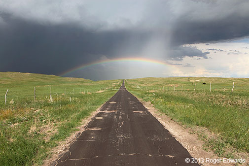
We jumped back S a few miles and let the storm’s main core (presumably containing severe hail) pass by us to the N and NE, offering a chance to observe the sunlit side. One of my favorite scenes all spring was the one-lane Sandhills blacktop with the rainbow arching over. Another was the rainbow seeming to drop right into a rain-soaked pasture nourishing contended horses.
Standing before the amazing beauty of that storm’s west side, I had an experience best described as immersively transcendent, completely one with the land and sky. After absorbing the full, surround-vision image of what was happening, I closed my eyes, standing with arms wide apart and upward, hands open, in praise for this great gift from above. Deep breaths fully drew in the clean, refreshing, rain-cooled and dampened air, with a sweet aroma of renewal and rejuvenation. Right then, the sun came out, unseen but certainly felt, warming my back comfortably. The easterly breeze of mild outflow, infused with just a few tiny raindrops, gently cooled the front side. The moment felt like a direct connection to heaven, harmony across all physical and spiritual sensations, lasting for probably for just a few seconds but seeming to be much more.
Every good moment has to end, so we enjoyed the last of that one, then headed off toward our lodging destination of CDR with some WY/MT storms in mind for the next several days. Along the way, we encountered some precip from elevated storms just W of Hyannis. We unloaded at our room in CDR (the Westerner Motel is highly recommended…American-owned and run, and very friendly folks!), then headed to the Country Kitchen on the hill for dinner with a view.
Sunset indeed treated us to a splendid display, looking SW across the rolling green hills of the Nebraska Panhandle at some weak storms that erupted on the outflow boundary in WY. I took that shot from the parking lot of the restaurant…told you it had a view! So concluded a marvelous day of storm observing and outdoor appreciation in the Nebraska Sandhills.
===========
Our PING trail for this day.