
Stormy Sunset Salvation
9 Jun 9
Northwest Osage County OK

SHORT: Killed Kay County supercell as it moved into Osage County. Intercepted complex multicell/supercell cluster from two sides near Webb City, with brilliantly sunlit convection astern.
LONG:
A couple days of prognostications indicated the best play on this day would be the frontal zone from the central high plains to the Ozarks, preferably W of I-35 where the road network and terrain each are friendlier. Analyzing the situation from our prior night’s lodging in SLN, it became screamingly apparent the too-well organized morning MCS was spewing lots of cold outflow and shunting the effective frontal zone well southward across south KS. The western part was being shoved into drier warm sector air with more westerly sfc component, while at least the middle segment seemed to be interacting with a sfc moisture plume characterized by mid 60s to near 70s F dew points. A mesolow also was forming W of ICT, potentially concentrating convergence in its vicinity from the area S of HUT through the ICT region.
Armed with that concept, we (Elke and I in one vehicle, Two Fogels/Two Dogs team in the other) headed for our target area of south-central Kansas, with a great lunch at the IHOP in HUT along the way. Scattered Cu dotted the SE-SW horizon in a band obviously corresponding to the outflow boundary. As we waited for initiation near Cheney Lake Dam, the boundary continued to sag S, and the winds actually backed from ENE to N. Oh no…the mesolow not only was riding the slowly progressive boundary, but moving E thereon! Meanwhile the warm sector winds to our S still remained out of the SW, with a more southerly component hanging in there E of PNC to BVO. Time to move SE and stay ahead of the mesolow…
As we cruised E from Conway Springs, storms erupted to our E along the boundary, and to our S over north OK. The former would have a shot if it could stay on the boundary (big “if”), while the latter erupted in the hotter, deeper mixed boundary layer, but more discrete with less undercutting potential from the outflow boundary. By the time we reached WNF, we decided to go after the Okie storm, now right-moving over Kay County all by its little lonesome.
Dodging a few small, transient left splits, we maneuvered with steely determination E and S toward Webb City OK, in the beautiful, green-carpeted, southwestern Flint (Osage) Hills. The storm maneuvered E toward our location, into better storm-relative sfc winds, larger hodographs, and lower LCLs, with a stone cold death wish…for itself. Just as we got in good position to its ESE: shrivelus convectus minimus!
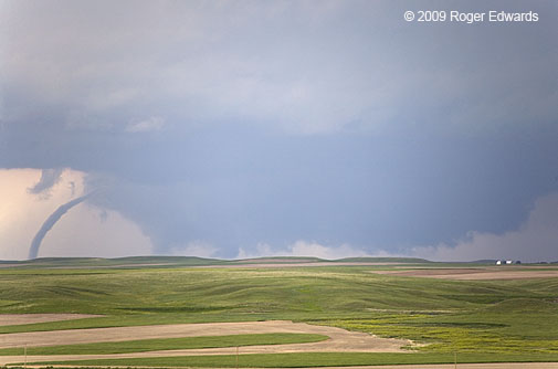
A messy complex of storms behind it, to our WNW-SW, became better organized, even sporting decent gate-to-gate mesos for short periods along a curving, embedded cyclonic shear zone. With sparse roads and a good W view (albeit with a hazy boundary layer), we let the initially distant assemblage of bases and cores — including one striated but small updraft cylinder — move our way. Very briefly — less than a minute, a finger of cloud condensate connected ground and ambient cloud base to the very distant WSW, but it was just too far away to ascertain whether this brief feature was rotating — a scudnado or the real deal. By the time I ran across the road for a better photo angle, it was gone.
After that, the storm cluster and its precursory anvil CGs drew closer, forcing our southward retreat to US-60. What appeared to be an anchor supercell on its SW flank grew feeble quickly (again, upon entering more backed surface winds and greater moisture…go figure), allowing us to “core punch” its moderately rainy and baseless carcass driving W on US-60.
By now, the sun was getting lower, and we decided to bunk down in PNC instead of driving up to 2.5 hours out of the way (to home), given the more western location of the next day’s forecast area.
The best part of the chase day, as often happens, came behind the storms, near sunset. The newly soaked, rolling green hills and valleys smelled a fresh and invigorating earthy aroma. Mild, moist air came to life with the calls of bobwhite quail and many wild songbirds, while a couple dozen nighthawks arose from the fields and flew off toward the setting sun.
Out across the big eastern sky, a beautiful double-rainbow festooned the back of the retreating storms to our E, followed by marvelous layers of light and shadow across the sides and tops of big new towers forming another anchor storm. Across a few fleeting minutes, the sunlight tones warmed considerably, reflections off the big towers in turn lighting those beneath and casting ever deeper hues across the scene. Finally the show ended, but not before a brief blaze of bronze from the final rays of the day.
It was a neat way to salvage an otherwise disappointing chase day and an egregious atmospheric underperformance compared to the 15% sig-tor outlook that had been issued for central KS early in the day. 😉
Surfing the Wake of the USS Hailbomb
Filed under: Summary, Uncategorized
A Tale of Two Supercells
7 Jun 9
Pawnee City NEb, to Bethany MO

SHORT: Intercepted Pawnee City supercell for a spell, then failed in prolonged attempt to get around and ahead of the hail-heavy Oregon City/Savannah MO supercell. Interesting structure on both storms.
LONG:
First off, we found out this day about the (non-weather related) road death in Iowa of storm observer Fabian Guerra. Though we didn’t know him, we offer condolences and sympathy to those who did. It was a simple but fatal deal of wrong-place/wrong-time that could happen to anybody who drives. Many of us in storm observing and outdoor photography have plowed into a deer (guilty here, twice) and/or swerved to avoid one, and simply were fortunate enough to maintain control of the vehicle and/or not have the animal come through the windshield. Never take tomorrow for granted!
As for the day’s chase… Elke and I headed for our target area of north central to NE KS — E to NE of the surface low and near the frontal zone. This was “synoptically evident” as they come, in the forecast sense; but mesoscale details (as often) threatened to mess up the chase day. Right as some of the best afternoon heating was about to take place, a thick plume of cirrus cast its deepening shadow overhead, an unwelcome visitor from above, wafted off a band of elevated, middle-level showers to our W and SW.
Despite this annoying development, no other area looked any better. Marysville, one of our favorite towns, seemed a good spot to wait for initiation, so we parked at the hilltop Wal-Mart for awhile in anticipation. The hail event the night before clearly was major, as shredded vegetation covered the ground throughout much of town, with windows broken in some houses and churches. DF and his cousin Samara (now the Two Fogels and Two Dogs chase team) joined us, as did a local spotter (Jamie) who followed us for a couple of hours.
Storms fired directly beneath the decaying remnants of the midlevel convection, in a short line segment from just NW of us (and over the NEb border) SSW to SW of Marysville. I’ll hypothesize that the cap, tremendously strong on the 12Z TOP RAOB, was weakened not only via columnar cooling related to large scale ascent, but also by evaporational cooling from above as the elevated, weak convection precipitated into the warm and dry capping layer.
One storm cluster — W of Pawnee City — seemed destined for good times, being on the boundary and in optimally backed flow; but it needed to shed the deleterious influence of junk storms to its immediate SSE. Meanwhile the tail-end storm (ahead of which we stayed for awhile) looked strung out and high based…a “wannabe” supercell. When the northern storm finally did lose its interfering garbage, it quickly acquired a deep meso and hook, so we targeted it. The tail-end storm fought disorganization for a couple hours, but would go on to become the V.O.R.T.EX.2-targeted Oregon City MO hailstorm.
Our Pawnee City storm gave us some good structure views through somewhat hazy skies, produced a few wall clouds (some weakly rotating), and even a nice RFD cut or two, but never could tighten up that well (wide-angle shot from 8 E Pawnee City, looking SW). We saw Chuck and Vickie amidst what he astutely termed the “cluster-f#&%” of chasers around that storm; there was so much traffic over a blind hill that I momentarily stood roadside to guide them into it.
Soon, the supercell began to get highly tilted and to shrink, while approaching the MO River, so we decided (perhaps a little too late) to leave it. Jamie the Marysville spotter, by then, left us to go home.
Meanwhile the southern storm, which we saw from earliest towers S of Marysville, suddenly was a somewhat sunlit eruption of thick, deep convection and anvil backshearing, beckoning longingly to us from its throne high in the southeastern sky. I never had much luck stern-chasing supercells in northern MO, given the hilly terrain, narrow and curvy roads, untimely towns and slow local traffic. Nonetheless, with a couple hours daylight left and some convincing from DF, we tried anyway…
Hard as we tried, with the river crossing and a tortuous maze of indirect, winding road options, we simply couldn’t get ahead of it without core-punching a rotating wall of hail that was visually apparent around the back of the hook. The hook seemed to park itself on every east road we wanted to take, right before we got there.
At one point near Union Star, a “bolt from the blue” struck less than half a mile to our S, several miles behind the hook and the flanking line. Less than twenty seconds later, we pulled over and I was outside shooting this image of a hailshaft on the backside of the supercell…but not for long, lest the storm recharge quickly and fling another supercharged bolt our way. DF and Samara must have thought I was nuts doing this just a couple of blinks after seeing Zeus’ pitchfork plow into the earth nearby. There was some risk, but probabilities were on my side if I didn’t linger too long out there.
While zigzagging constantly astern of the heavy frozen-cargo vessel USS Hailbomb, as if dolphins surfing back and forth through its wake, we indeed did see some huge stones (greater than baseball size or at least 3 inches diameter). The gorilla hail lay in the grass at Oregon MO amidst shredded vegetation, but we didn’t stop to measure due to the continuing chase.
We finally got near the back side of the hook near Maysville, taking decisive visual measure of a churning merry-go-round of rain and hail curtains orbiting some unseen circulation center to our immediate east. With tornado reports (even if they later turned out to be bogus “sheriffnadoes”) coming from inside that bear’s cage, we decided not to punch through. Instead, at sunset, we finally took the long way around, down to US-36 to Cameron and up I-35 a few miles toward Bethany, but still couldn’t get ahead. That’s when we waved the white flag and let the storm march off into the northern Missouri night.
Some attempts at lighting shots ensued (a decent but not outstanding one, and a better opportunity that I slightly overexposed, unfortunately), along with some conversation with Alnado there, and we headed back toward lodging at STJ. Along the way W on US 36, a dense flock of heavy storms developed atop the supercell’s outflow, coring us repeatedly with blinding rain and intermittent small hail.
A pretty decent chase day was capped off by finding a live brown recluse spider in our room at the Super 8 in St. Joseph (where Charles, Rocky, Bill Hark, Dave Lewison and other chasers also were staying). One of the girls staffing the front desk was frightened almost to panic by it. The other took it in stride, saying, “Oh yeah, we’ve got those all over our house.” At no point did either of them think to apologize or offer comps to this particular customer. I fed the fiddleback to a black widow spider from Oklahoma (my yard, specifically) that DF was carrying around as a sort of chase mascot this year. I also talked to a truck driver in the lobby who had lost all his window glass to what he estimated to be softball sized hail at Oregon City earlier in the day.
Wyoming-Nebraska Tornadic Supercell
Filed under: Summary, Uncategorized
5 Jun 9, Bushnell to Gurley NEb
SHORT: Intercepted mature supercell with tornado in progress in SErn Goshen County WY, looking NW from N of Bushnell NE. Spectacular rope-out followed by several structure photography stops over the course of a few hours, before landing in OGA for the night.
LONG: We began the day in HYS after driving up from Norman the day before, when I had no sleep all night the 3rd or all day the 4th. We slept in at HYS as a result…maybe a little too long. The target area was fairly well focused — the CYS Ridge region and any convection that might erupt off the southern LAR range. Unfortunately for us, the farthest possible zone within the target area was where it erupted, but we managed to salvage the day anyway.
Flat “pancakus” Cu hovered over the CYS ridge to our N as we approached Wray CO, with dense cirrus overhead limiting heating. Meanwhile some small echoes began to appear near the LAR range NW of CYS. After a quick service stop in Holyoke, one of those echoes (the eventual La Grange WY storm) was starting to get a compact and intense core, with no apparent sources of convective interference to its S,either in VIS or reflectivity imagery. Off we torn. By now the storm was starting to look supercellular on radar, and we had to haul west on I-80.
Once we got past SNY, a darkened, elongated smudge appeared under the cirrus deck to our WNW, and tornado warnings began. Keith had called DF to let him know that the storm was about to produce, and we made good time along the Interstate toward the WY border. We turned N through Bushnell onto a road that DeLorme indicated was paved…but it became gravel and hard-packed dirt.
About 2-3 N of Bushnell and barely E of the WY border, we began to see the tornado on the SW edge of a broad wall cloud — a nearly vertical stovepipe with some precip and/or dust around the condensation funnel. By the time we found a good vantage a few minutes later — a hillside ~5 N of Bushnell, the tornado began to narrow into a tapered, curved cone. By the time I pulled over, got out, ran to the other side of the road and hoisted the camera, it already was in transition through elephant-trunk (wide-angle and with zoom lens) to rope stage, at the S edge of a gigantic, ragged wall cloud.
This was Emily’s very first tornado, which earned her a vigorous high-5 from me. It also was Elke’s third birthday tornado, a most fitting atmospheric present for her. Finally, this was the second time that Elke, DF and I had seen a tornado in one state from a different state (the other being in Montana but seen from North Dakota on 6 Jun 5, the infamous “Ekalaka Smacka Backa” chase). We admired and photographed the narrowing then roping tube from a distance, watching the sinewy condensation funnel rope out in a spectacular arc, then finally split into segments and die quickly. We had seen a little under half of its lifetime, based on others’ accounts. After the long and pounding haul from HYS, we felt very fortunate to see even the last 7-8 minutes of its lifetime.
We then headed E on some unmarked, mainly gravel roads, eventually meeting up with some folks including Hodo, MattC, Rocky, Charles, Alnado, and a few others who had the privelege of witnessing the tornado from closer and/or longer time. We also had the pleasure of talking with Dave Hoadley, who saw the last few minutes of the tornado from even farther away, N of Kimball. Gotta love that long High Plains visibility!
After it paid the tornado troll’s toll for entry into Nebraska, the supercell as a whole became somewhat ragged, but still well-defined and visually pleasing. A couple of occlusions along the way E yielded moderately rotating wall clouds — one extruding a conical cloud lowering that spun slowly, as if trying to tighten into a funnel. Another lowering later, NNW of Kimball, briefly stretched into a ragged but definitely rotating funnel with no apparent debris beneath, way back in an old occlusion to the NNW (looking N under newer wall cloud).
We then got road-screwed and had to drop S to I-80, whereupon we bid farewell to DF and Emily (who had to fly out of ICT early the next morning), then headed back N out of SNY to watch the storm some more.
By the time we got back on it, near and E of Gurley, the supercell had acquired a messy underbelly with a ground-scraping wall cloud, beneath a highly tilted convective plume, and fronted by a skirt of striated cloud material. The storm cast a long, sharp shadow to the ESE while spinning over the beautifully verdant wheat fields of southwest Nebraska, and later, posing before a deployed sticknet.
Soon it was getting dark, so we went SE to OGA for the night, whereupon we got fast-food dinner and a motel room, then began hearing reports of nighttime tornadoes from “our storm”, headed right for OGA! We bailed S of town a few miles to spot. A new, tornado-warned supercell to our E took over and sent a raging pool of outflow toward us, killing the long-lived LaGrange-Gurley supercell at last.
We worked hard for everything we saw on this first chase day of the vacation, and slept well that night, bathed in gratitude and satisfaction for a pretty tornado and some grand displays of supercell formations along the way. What a fantastic way to start a grand June 2009 storm-observing odyssey across the Great Plains!