
Imperial Ride
Wray CO, Imperial NE
24 May 13

High Plains Therapy, Day 1 of 5
SHORT: Left Norman 8 a.m. Intercepted three funky small supercells between Wray and the IML area, shot what appeared to be elevated supercell at sunset N IML that got sfc-based and happy after dark NE of town while I was eating a fajita-stuffed pineapple at an IML restaurant. Paid tab, zipped out onto remote sand roads (glad to have high-clearance 4WD!) but couldn’t see anything of note beneath; shot DSLR sequence for time lapsing as it receded into distance.
LONG:
My usual storm-intercept partner for the month was back at work. My other usual chase partner (Elke) had work to do at home. I just had experienced three frustratingly futile jaunts amongst non-tornadic storms that were close to violent Kansas and Oklahoma tornadoes that I didn’t see. Extraordinary and violent tornado damage had ravaged areas not far from home; Elke and I had done some things to help. Five days remained in my May vacation leave, and other friends were out, with whom I could link to caravan. The near-term to extended forecasts showed some concerns about moisture the first few days, but that a favorable pattern for supercells would exist somewhere up and down the Great Plains for all five days I had left, through the 28th.
You know what that means: go time.
High Plains Therapy was working from the moment I left the OKC metro area and its grim tornado damage behind. The open sky above and open roads below beckoned–long blue highways rolling over the rises, down the slopes, and straight to the horizons. The journey, at least as important as the destination, unrolled bales of pent-up frustrations and angst from my soul, straw by embedded straw, as northwestern Oklahoma and southwestern Kansas glided under the wheels. By the time I reached the Bucklin and Jetmore areas, it was time to make stops to stretch and appreciate the grandeur of the Plains and the prairie wind. These were extraordinary blessings, as were opportunities to stop and shoot abandoned farmsteads (example images: one, two, three, four, five, six, seven).
Leaving early offers advantages in the form of time for exploration beyond the frantic rush to the target for storm initiation, which for today was the Wray CO/St. Francis, KS area. Low-level convergence along the northern fringe of a dryline segment, backed flow advecting moisture upslope into NErn CO, low-60s dew points into CO, strong afternoon insolation, and 40-45 kt deep-shear magnitudes supported a supercell potential with any convection that could fire in that area. After the abandoned-farm photography stops, it was time to zip up to and along I-70 to GLD, then fuel up in St. Francis–right in time for towers to form from SSW-NNW, just as envisioned.
Westward to Wray I went, bypassing an initially promising-looking storm to the immediate south whose base was shrinking and getting fuzzy. Two cells N of Wray, very close to each other, both grew and were looking promising. Here I was in northeast CO, watching two newly minted supercells at once, after leaving Norman early in the morning…how could I complain?
Loping northward along US-385 toward Holyoke, I monitored both updraft areas from several stops as they cruised toward the NE, then ENE. Mostly sub-severe hail fell in Holyoke from the vault region of the still-small western storm, with isolated, marginally severe stones (PINGed). It was easy to get out of that heading E on US-6, then slightly S, before hitting the NEb border.
For a long time, these two cells were engaged in a classical dance of mutual interference–the eastern one was pumping rear-flank outflow into the path of the western one, and the western storm was dumping anvil rain into the eastern storm and the latter’s inflow. These silly games needed to cease for either to robustly take over! Eventually the western storm did, as the eastern one became more elevated and shriveled away.
By “taking over”, I mean “survived” more than “thrived”. The western storm, though intermittently sporting a supercellular appearance, remained rather ragged and hardly looked like a world-beater, especially with a lot of convection firing to the N, NE, E, and SE. After stopping briefly to photograph a cute little abandoned shack near the border, I headed into NEb to intercept a much more intense and newer storm apparent both visually and on radar, SSW of IML. I wheeled through IML, then S of Enders Reservoir, while managing to keep an eye on the original western storm in my rear-view (or with occasional NW glances).
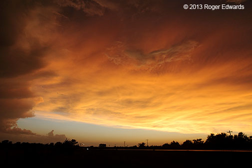
Alas, cell mergers and precip had turned the newer storm to diffuse mush by the time I intercepted it S of IML. Nonetheless, it left a refreshing, cool, slightly breezy puddle of outflow air that I appreciated and relaxed in, for a few minutes, before heading back toward IML for potential sunset light. Arriving in town before sunset gave me time to reserve the last available room at the back of cheapest motel in town, then head out E again several miles to behold the magic hour.
Wrongly, I figured the outflow air would be ingested by what was left of the original western supercell, finally putting it out of its misery. Instead, the storm persisted and moved just N and NE of IML as an elongated, elevated saucer–not mind-blowing gorgeous but still very pretty and much-appreciated. I shot that and this image], among a few others, while that slowly modifying outflow pool blew across my back and beneath the storm that refused to quit.
Fading daylight, increasingly nebulous storm structure, the ultimately misguided notion that it didn’t have anything substantial left to offer, the banging pangs of hunger, and the supposition that any restaurant(s) in town were soon to close, all combined to send me back to my room to unload and find food. Mission accomplished: within half an hour I was sitting contentedly in Tequila’s Mexican Grill (the only place still open that wasn’t a gas station), very satisfied to be mining a delectable abundance of shrimp, steak strips, chorizo, and fajita vegetables from a hollowed-out half of a pineapple. I strongly recommend this place for those who find themselves hungry in Imperial at dinner time. The Mexican food was surprisingly good for Nebraska, the price was very reasonable, and service was splendid.
Quick checking of radar showed that what was left of the elevated supercell off to the ENE was…quite possibly not elevated anymore, had a sharply defined reflectivity hook, a modest velocity couplet, and was tornado-warned! I almost choked on the chorizo. This sucker had shed the outflow and latched onto a much more favorable airstream from the low-level jet. Fortunately, I was able to pay the tab fast, wolf down what was left, and trek off into the darkness toward the retreating storm.
Stern-chasing a nighttime supercell on sand roads normally isn’t recommended, but sky visibility was good, the roads ENE of IML were fairly wide for awhile and, thanks to the sand being wettened and packed down some, traction was manageable. Tactical driving with a high-clearance 4WD was much like on the tidal zone of beaches at Daytona or North Padre.
Unfortunately, the storm appeared to be accelerating ENE again and merging with other convection by the time I got close enough to make out its back side well, and road options were becoming more sparse and narrow. I stopped to set up the tripod and shoot
what was left of the supercell–demarcated by a pronounced max of in-cloud lightning within a broader complex of storms–receded in the direction of toward North Platte or Lower Michigan.
Lightning itself was rather unspectacular, but still much appreciated. There’s something enchanting about comfortably mild blend of return flow and remnant outflow air, a remote High Plains road at night with nobody else around, crickets and distant thunder as the only sounds, and a flickering nocturnal sky increasingly suffused with filtered moonlight. It felt like just me and God out there.
Here’s a time lapse of that scene that is worth watching but that still doesn’t do justice. Warning–if all the flashing in the old Wang Chung music video gave you problems, this might too!
Day-1 of High Plains Therapy was every bit the antidote it could be–a soothing cataplasm for lingering chase wounds, but one still demanding daily changing for full healing. And so it would be…
Strike Three (Time for New Game)
Lindsay and Elmore City OK, St. Jo TX
20 May 13
SHORT: Strike 3, batter out for this system. Intercepted 3 supercells in 3 tornado warnings and 2 states, saw no tornadoes: 1) Lindsay OK, 2) between DUC-PVJ, 3) near St. Jo TX.
LONG:
Setting up “the day after the day after the day before the day”
Somehow, on consecutive Kansas/Oklahoma tornado days, we had come up empty-handed in that regard–and worse, with very few decent photos or positively memorable experiences to show for it, despite multiple storms intercepted. This third chance, a cold front was moving very slowly SE across central OK, into an air mass characterized by upper 60s to low 70s F surface dew points, and strong surface heating. Many long-time, seasoned storm observers, in their pre-chase forecast musings, targeted the cold-front/dryline triple point area, forecast to be near FSI by late afternoon. Rich T and I wanted to hang a little closer (CHK area) for starters, but as it turns out, not even that was “close” enough.
My last forecast offering before hitting the road summed up the pre-chase situation fairly well:
-
In some ways, this is a messier, more difficult chase-forecasting scenario than previous two days, and we still somehow avoided all the tornadoes on them. What does today have in store?
Could be an early-initiation scenario (relative to previous days), especially on the “northern” end of the regime from the CHK-OKC area NEward, given positioning of the upstream shortwave trough, high CAPE, rich low-level moisture and likelihood of CINH eroding fairly quickly in SSW-ward zippering fashion. This looks like one of those patterns that support fairly quick SWward backbuilding after initial mode of relatively discrete storms. Two big questions to answer today:
1. How long will discrete mode last?
2. Will storms go too early and get messy while the warm-sector flow still is somewhat veered, and before low-level SRH picks up later in the afternoon?
Rich and I were rather worn out from the two prior days, but decided to head out anyway, given that the threat was within a couple hours’ drive of home. By the time we left, shortly after 1 p.m., deep towers already were building along the cold front W and SW of the OKC area, and along the dryline farther SW.
What was and could have been
Migrating our way SW, we noticed two main areas of development–a multicellular splotch near FSI (later to evolve into the DUC-PVJ supercell) and a more discrete, fast-growing echo SSE of CHK, headed toward PRC. The latter was closer, moving into a high-CAPE, moderate-shear environment, and more isolated, so we migrated that way for starters. A nice vantage from just E of Lindsay offered this early view of the young storm to our WSW, still small and beginning to fall under the anvil shadow of the FSI-DUC cluster (the latter’s anvil being visible at distant left).
Had the Moore storm formed either first, or a little later (with more time to get there), we might have targeted it instead. However, it developed to our NNW near Blanchard, with a rather ragged early look for such a big-CAPE day, as seen through the anvil precip of the Lindsay storm. Being in the immediate inflow of the latter, which still held some promise of growing and maturing, we held position.
Questions about our storm’s current and future integrity arose with the dramatic sharpening of the appearance of the future Moore storm, the narrow updraft of the Lindsay supercell as it moved nearby to our NW, and the rain falling into the latter’s inflow from the anvil of the DUC cluster.
Before long, the Lindsay supercell weakened dramatically, leaving us sitting there stormless with this decision: zigzag back NNE to I-35 and try to catch the northern storm, now tornado-warned and sporting a hook as it moved toward western Moore, or head S on a more straightforward path to ahead of the consolidating and closer DUC convection, by now also sporting a radar-indicated mesocyclone and moving NE (much faster approach). Chasing in the metro area also was considered a negative; so we turned S.
Soon after doing so, we heard a frantic TV simulcast over the radio describing a growing and potentially violent tornado moving into Moore. This was terrible news on multiple fronts. Moore had been devastated multiple times in the past 15 years, and this was the last thing they should have to deal with. Secondarily, we were getting the vibe that, for the third day in a row, it just wasn’t our day to see a tornado (despite not reaching the DUC storm yet).
We still had time to do a quick turn-around and maybe catch the Moore storm after it crossed I-35; but stern-chasing a destructive event through the suburbs seemed rather unwise. By contrast, Elke, who had stayed home and was watching the event unfold on TV, was able to get a safe, in-person peek of the last few minutes of the Moore tornado simply by driving a few miles N and finding a hillside vantage (E. Franklin Rd E of 36th Ave). Some trees and terrain were in the way, but she watched as the Moore tornado (by then well E of I-35) appeared to her NW, narrowed, then roped out in wild, loopy fashion.
Meanwhile, an hour to the south, we simply had to digest the fact that we were missing what sounded like the worst central OK tornado event since 3 May 99, while also hearing a report of a brief tornado from the DUC storm that we hadn’t reached yet!
Post-tornadic DUC-PVJ supercell
Heading W out of Elmore City, we caught the former Duncan-area supercell W of Foster. Finding reasonable vantages was difficult amidst the shoulder-deprived roads, hills, trees, an abundance of both real and imitation storm chasers taking up the best pullouts, and storm structure that looked very wet and messy via glimpses through the obstructions. What was left of the main mesocyclone got wrapped in rain and lost its identity NW of Foster, as very heavy showers flooded the main supercell’s inflow region with their own stabilizing effluent. A newer meso seemed to get undercut as it crossed the road nearby, and as we experienced cold RFD outflow to its immediate SE.
Nonetheless, the storm tried, amidst all the convective-scale slop, to maintain some supercellular identity as it headed ENE between Elmore City and PVJ. This view, looking NW, was about its most robust appearance, with moderate visual rotation and a concurrent reflectivity hook on radar, before it crossed I-35 just N PVJ. After short deliberation in town, we let the gradually shrinking storm go, and plunged S on I-35 to intercept whatever would remain of a big North TX supercell located SE of SPS. It was either that or give up and crawl home in shame. Not being easy quitters, we decided to make a go of it.
Takin’ the Tejas plunge and back
Radar showed the Texas storm right-moving toward Muenster, so getting safely ahead of it would be easy at legal Interstate speeds. First, however, we had to reach to a spot just S of the Arbuckles before the front wall of a formerly discrete supercell–by now a messy storm tangled up with a large load of other convection, and dominated by a deeply rain-wrapped/forward-flank circulation. We beat that electrically active mélange of amorphous slop by just a few miles (structure so fuzzy it wasn’t worth a photo stop), then proceeded across the Red River. A left-mover we had been monitoring SSE of the storm was closing in fast, leaving us with (at best) a narrow window of potential before mutually assured convective disruption.
Turning W on US-82 aimed us toward a dramatically darkening and increasingly lightning-splashed western sky. After we left Gainesville, the former fuzzy mess that we had ignored got tornado-warned NE of ADM. That’s right–kick us while we’re down!
Between St. Jo and Nocona, we found a temporarily good place to park, as the supercell–by now an HP stormzilla into which the large left-mover already was ramming with great force–closed in. While waiting, we encountered Matt Crowther and Vince Miller, and had a short but nice chat with them.
When the approaching half of the sky looks like this, and then several minutes later, like this (notice the long line of fleeing vehicles), it’s not a wise idea to stick around sipping frosty brews and smoking Cuban cigars from the comfort of lawn chairs. Having no such suds, smokes or seats anyway (just shamefully seldom-used cameras), we high-tailed it E back to Gainesville. Meanwhile, ransacked by all the cell mergers, collisions and outflow, the formerly imposing storm became a gusty heap of rain and lightning. Whataburger time…
We ate, let the heaviest part of the cores slide by to our N, then shot the convective gap northward before some heavy, training and elevated storms reached the Marietta/ADM area. Some beautifully colored sky, just before and after sunset, greeted us near Springer. That offered but a small modicum of cool relief on part of what felt like a substantially large chase burn. By the time we rolled back N on I-35, in despair over the disaster in Moore, and with Rich’s chase vacation having ended on three straight swing-n-miss days, we were quite ready to carry out the sentiment expressed by the following quote from 2006…after all, our chances of seeing Sasquatch seemed greater at that point.
-
“Let’s forget this tornado chasing and go look for Bigfoot.”
There still was some vacation time left for me, however. Soon, I would desire (and embark upon) some much-welcomed and soothingly corrective “High Plains Therapy”.