
High Plains Lightning Festival
Colorado-Nebraska Border Region
13 June 11

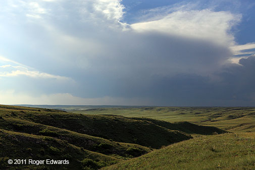
SHORT: Began in BFF. Waited in SNY. Avoided outflow-surfing CO/NEb border storms to intercept supercell near AKO, saw probably non-tornadic dust whirls with storm merger there. Fantastic twilight lightning display from elevated storms along border S of IBM.
LONG:
Elke and I started the day in BFF, targeting the general area of the CO/NEb border SE of there. I wasn’t particularly jazzed by the weak lower-tropospheric winds in the forecast, figuring outflow and/or storm splits would be a problem. Still, it’s the high plains in early June with adequate moisture, upslope flow and at least marginal shear. The answer? Be there.
We waited a good, long time at a hilltop outside SNY, just NW of a dryline that eventually would fire up a tornadic HP supercell in the horrible road network and terrain of the Sandhills. We saw those towers to the distant NE, but chose not to pursue given the great difficulties involved with storm intercepts in those parts.
Meanwhile, we listened to meadowlarks and, on radar displays, watched chaser icons on SpotterNetwork zigzag back and forth across the area in impatience as the lack of focused action. Fuzzy storms began to fire between the Laramie Range and Cheyenne Ridge, which was no surprise; their distant bases were so high we could see them from SNY. I wasn’t impressed. Red dots converged on I-80 and headed W. We sat, waiting and hoping instead for dryline development to access richer moisture to our SE and E.
Finally, off to the distant SW, two storms erupted near and N of the Palmer Divide in Colorado. This was near the very southern fringes of our forecast area; but as nothing much was happening with the dryline nearby, and the storms were reachable, we decided to go have a look. Along the way SW, through the convoluted maze of roads that is Sterling CO, the southeast storm attracted quite a few chaser icons. The NW storm didn’t, was closer, and was in a similar environment; so we headed toward AKO to intercept it.
Alas, along the way, the SE storm calved off a big left-mover and died! Moreover, the left mover shot toward the inflow region of our target storm like a torpedo hell-bent on mutually assured destruction of both storms. Briefly, we got a view of the NW supercell’s mesocyclone area to our WSW before the left-mover’s core arrived; and it looked like a somewhat higher-based version of a North Texas HP “Stormzilla”. This meant big hail; so it was imperative to get S fast.
Yet there loomed the left-mover over the road to our S, likely bearing ice bombs also. It got there as we did, just S of AKO. The two storms started to merge overhead, and in the tiny gap between their cores, two strongly rotating dust whirls appeared less than a mile to our W, about 3 minutes apart. [I was driving and driving hard, so…no photos!]
Though a narrow, ribbon-shaped updraft had formed overhead at the merger location, we could see no obvious rotation in it. I attributed the whirls to gustnado-like vortices being stretched where the two gust fronts met. We maintained an equatorward bearing, encountering only marginal severe hail at best (to our relief).
Arriving just S of the combined storms, which indeed were killing each other, we photographed the dying supercell across rain-drenched corn stubble S of AKO. It was good to see Steve Hodanish and to swap Hodo stories with a co-worker of his, and also, to talk with a few other friendly storm observers whom I hadn’t met before. Yet we were essentially stormless, parting ways and headed back toward our various bases for the night. All that was left, for now, was outflow spinning a windmill under a dark and stormy high plains skyscape.
We headed toward lodging in the Nebraska Panhandle, soaking in the sights of Pawnee National Grasslands in anticipation of spending a couple of upcoming non-chase days of roaming around some of our favorite haunts around the Black Hills, not counting on any more atmospheric excitement. As good fortune sometimes plays on previously under-performing storm days, the night brought about an unexpected–and most welcome–show of splendor that made our night!
A short line of elevated and high-based thunderstorms erupted over the WY-NEb border region atop the outflow pool from all the late-afternoon activity, and moved SE across the southwestern Panhandle and across the Cheyenne Ridge. Evening storms like this in the High Plains can spark profusely, and these absolutely did! We found a vantage just over the CO/NEb border S of IBM (Kimball, not the company) and began shooting away at the approaching spectacle. Assorted forked and in-cloud displays slashed across the fading twilight, their reports blasting resonantly across the wide-open landscape. Soon, some cloud-to-air discharges flickered forth, followed by yet more (and closer) sky-splitting CG action. Wow…what a show!
The lightning was getting too close, though; so we drove through the translucent core of the thunderstorm line a short distance into IBM, crossing a few miles of small hail (with almost no rain!) along the way. I’ll never forget the sight of countless thousands of little white hail balls in the high beams–cascading dots of brightness, the only form of light shining back at me along that dark High Plains highway.
After securing a motel room near the edge of town (like we like to do), we noticed the sparkling display still underway to our SE, and headed back out past the E edge of town for a little crawler-lightning show in the trailing precip region. And with a few more flashes to light up the midnight hour across the western Nebraska prairie, bedtime drew nigh, our storm-hungry palates duly satiated. I had very few lightning photos to show for 2011 until this night, when the heavens unloaded electrical gifts one after another in a most dazzling and appreciated fashion.
A Championship Day (Even if Not for Storms)
High-based Storms in the Nebraska Panhandle
12 June 11
SHORT: From LBL, headed to the BFF area for high-based upslope action. Observed a few such storms from between BFF-AIA.
LONG:
The day wasn’t too spectacular convectively, but we saw storms and had a great time nonetheless.
Morning dawned to the analytic display of foci that were somewhere between muddy, nebulous and vague on the spectrum of precision. The surface map showed that the isodrosothermal field had been mangled by overnight and morning convection over southern Kansas, east of where we spent the night. When all else fails, the terrain just isn’t going anywhere–at least not for the next 20-30 million years or so.
We therefore headed toward the reachable area of the NEb Panhandle/NE CO, figuring that 50s F dew points in that area sometimes do good things as long as deep-layer shear is at least marginal. It also put us in position for day-2. Plus, Elke and I love that area for many nonconvective reasons.
After visiting an abandoned shack in western KS, we found a nice hilltop vantage about 5 SW Angora NEb, listening to assorted birds and photographing wildflowers (e.g., copper mallow, western wallflower, and veiny dock), as we waited for convective eruptions.
Assorted towers and turrets soon bubbled up to the W and SW. One persistent pile to our W evolved into a short-lived, high-based storm with a wall cloud to our NW, viewed across the rippled orographic musculature of the Nebraska Panhandle’s ash-bed grasslands. The storm exhibited weak cyclonic shear in the midlevels based on radar velocity output, but just for a few scans.
Other, smaller, junkier cells fired along the foothills in SE WY and over the western reaches of the Wildcat Hills to our SW, amounting to little except as a scenic diversion for aviators. We saw several contrails weaving between storms, including this scene over Minatare. The storms died off with the setting sun.
We settled into a charming little mom-n-pop motel in BFF with funky walls made of green quartzite from Utah. This also was the memorable night my hometown Dallas Mavericks won the NBA championship too–making up for a disappointing evening 5 years before in GCK when I watched them lose it to the very same team.
A very fine day, indeed…
Mesmerizing Mammatus Moments
Pritchett CO Supercell
Assorted Storms and Sunset from Boise City OK to Liberal KS
11 June 11

SHORT: From McPherson KS, drove almost directly to Pritchett Co, saw brief tornado with supercell due W but no photos due to untimely town transect. Supercell died, as did another SW of Boise City. Intercepted back side of Turpin storm, photogenic outflows from trailing squall line. Amazing mammatus sunset followed by fun dinner with CoD crews in LBL.
LONG:
This was a splendid first day on the High Plains for us in 2011! The day after hanging out in the beautiful Flint Hills, Elke and I headed W out of McPherson KS on the most direct route bypassing DDC to our target area of SE CO. We stopped along the way just briefly for fuel and to photograph an abandoned shed.
As we got to Syracuse KS, storms already had formed N of the RTN Mesa and W of US-287 in CO, our decision being to intercept the northern storms in a better road network, or the southern, newer storms that promised more unimpeded inflow for longer. We quickly decided on the latter and went S and W through Springfield to Pritchett.
Despite the densely wrapping hook echo on reflectivity displays, we didn’t expect anything substantially tornadic from the southern storm W of Pritchett, which by now had evolved into a mature, intense but high-based supercell. Alas, right as we started to enter town from the N, Elke noticed a conical funnel under the base to our distant W, protruding about 1/3 groundward, with a dust whirl beneath and thin, translucent debris sheath extending between dust whirl and condensation funnel. Of course, it had to be while we were trying to get through the only town within many miles; and I only caught a couple of brief but unmistakable glimpses between buildings. So did a cop; for staring that direction, he tore out of a nearby alley, sirens and lights blaring, briefly blocking the road before drag-racing Duke Boys style around a gas station and vanishing in a dust plume of his own making.
By the time we exited the S side of town, the tornado was gone–no photos, only memories. All visible vortex traces vanished into Colorado-thin air before I could call it in; but I did so anyway. The PUB forecaster seemed relieved that the warning verified, even if by a brief cheezenado.
We cruised W to an observing spot E of Kim, admiring mammatus to our N more than the increasingly featureless and drab storm now devolving to our W. A broad mass of showers and thunderstorms was growing to the older storm’s SE and dumping cold outflow into its inflow–certain doom for a once-powerful and briefly tornadic storm. Where next? Plenty of daylight, and we were storm-orphans. Cells were firing in the north-central Panhandle of OK, far away but reachable; and we could see the anvil of a persistent, solitary but undoubtedly very high-based cell to our S in NM. We had to go to Boise City for a chance to peek at either; so back we headed to the far fringes of our current home state.
Fifteen to twenty minutes spent at the front of a stopped line of vehicles, waiting for a flagman and pilot car on US-287, either cost us an inflow view of an intense supercell later or saved our necks; I’m still not sure which! By the time we got out of that, the remnants of the NM storm passed by CAO and came into view–not surprisingly, a widespread virga bomb dumping downbursts…albeit a wonderfully textured and photogenic virga bomb.
After fueling in Boise City, we targeted the supercell approaching LBL along the KS/OK border, glimpses of which we could see to our distant E and ENE ever since being stuck in the conga line on 287. Along the way to GUY, I couldn’t resist quick stops for two Great Plains specials: a striking scene of an abandoned barn high in late-day sunlight, as if sailing through an ocean of golden wheat, and from N of GUY, a high-based but beautiful Cb to our distant SE near Booker (the next storm W of what became the Follett supercell).
We headed NE from the GUY bypass toward Optima, greeted by the development and maturation of a pretty front-lit and under-lit arcus from the tail end of a short squall line to our W, NW and N. The earth, desperately dessicated and thirsty as you see, was about to get a much-needed drenching and quenching.
That’s what was happening behind the “Liberal-Turpin” supercell that, once we got to Hooker, was E of the road, sitting directly astride US-64 between Hooker and Turpin. Its meso wrapped across the highway to our E, blocking ready access. Police had US-54 blocked heading NE toward LBL, probably because of (by now) very old information about the supercell; so we turned E toward Turpin, creeping up to the back side of the raging HP monstrosity, able to see only scud and wrapping precip rolling southward in surges around the otherwise unseen mesocyclone. I knew what that meant, and considering past lessons, we weren’t about to core-punch it for any price or dare.
If we had arrived 15-20 minutes sooner, without the earlier traffic blockage N of Boise City, we might have made it; but then again, we also might have missed the amazing sunset show that followed. And that would have been a damn crying shame!
Instead of pondering could-have-beens, we admired still more outflow, this being the curiously lit E side of the arcus from the squall line to our N, looking past Hooker. We let that shelf roll over us for some eerie illumination, then plunged through the wet but harmless band of precip to get to our lodging in LBL.
As we entered LBL, it became glaringly obvious that a spectacular sunset show soon would ensue on the back side of the storm complex. The low, golden sun shone through the last curtains of trailing precip, and also through those, we already could see a field of mammatus aloft through chunks of ragged scud clouds evacuating eastward.
We secured our room keys from our favorite little motel there, then headed N of town for a gorgeous Great Plains sky of sunset mammatus that made the entire convoluted trip, every minute of it, worth its unforeseen destination in images such as this. Yet photos, beautiful as they may be, only can convey two dimensions of one sense: vision. This was not just a scene, it was an experience.
Land parched by drought sprang to life in a soothing blend of sound and aroma, cool and moist, as thoroughly refreshing to me as to the dozens of western meadowlarks celebrating in song across every compass point. I longed for the physical capacity to inhale ceaselessly, so as to miss not a millisecond of moist, earthen scent flowing across cool breezes, while sunset’s golden and reddening glow reflected first off the moving tapestry of mammatus clouds above, then off the land below and all around. For a fleeting few minutes, arms spread wide into the breeze, eyes gazing aloft, ears in stereophonic reception of the avian chorale’s cheerful spontaneity, smells of freshness and cleanliness and life, I ventured into a timeless place far outside the confines of self. It wasn’t the first time under such circumstances, either.
Let me assure you, when you are open to releasing your shackles of distraction and worry, and diving headlong into an experience of this nature, every sight, sound and breath swirls together as one multidimensional immersion in full appreciation reaching far beyond words and images. It’s a conscious decision, a gift to accept, an act of release and absorption, letting go and drawing in. These are the occasions when we let go unconditionally, in spiritual as well as sensory ways, bathing in a rejuvenation of sorts that cleanses all accumulated grime from even the farthest crevices of our being. If this is but an ephemeral and incomplete preview of heaven, count me in when the time comes.
Then came the slow descent back into reality, as the colors faded and a growling stomach begged for tangible nutritive sustenance. I noticed, via SpotterNetwork, that Paul Sirvatka and the CoD crew were headed into LBL from the S, so I called and invited them to join us for what turned out to be a fine dinner with enjoyable company.