
Wyoming-Nebraska Tornadic Supercell
Filed under: Summary, Uncategorized
5 Jun 9, Bushnell to Gurley NEb
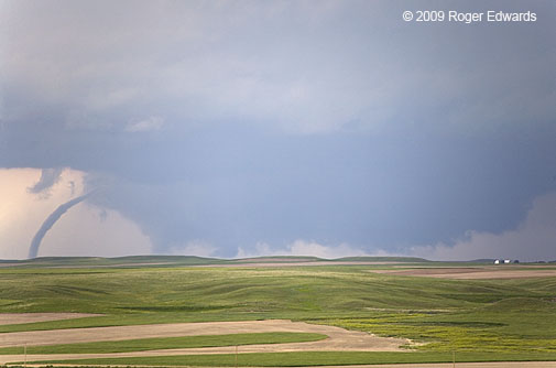
SHORT: Intercepted mature supercell with tornado in progress in SErn Goshen County WY, looking NW from N of Bushnell NE. Spectacular rope-out followed by several structure photography stops over the course of a few hours, before landing in OGA for the night.
LONG: We began the day in HYS after driving up from Norman the day before, when I had no sleep all night the 3rd or all day the 4th. We slept in at HYS as a result…maybe a little too long. The target area was fairly well focused — the CYS Ridge region and any convection that might erupt off the southern LAR range. Unfortunately for us, the farthest possible zone within the target area was where it erupted, but we managed to salvage the day anyway.
Flat “pancakus” Cu hovered over the CYS ridge to our N as we approached Wray CO, with dense cirrus overhead limiting heating. Meanwhile some small echoes began to appear near the LAR range NW of CYS. After a quick service stop in Holyoke, one of those echoes (the eventual La Grange WY storm) was starting to get a compact and intense core, with no apparent sources of convective interference to its S,either in VIS or reflectivity imagery. Off we torn. By now the storm was starting to look supercellular on radar, and we had to haul west on I-80.
Once we got past SNY, a darkened, elongated smudge appeared under the cirrus deck to our WNW, and tornado warnings began. Keith had called DF to let him know that the storm was about to produce, and we made good time along the Interstate toward the WY border. We turned N through Bushnell onto a road that DeLorme indicated was paved…but it became gravel and hard-packed dirt.
About 2-3 N of Bushnell and barely E of the WY border, we began to see the tornado on the SW edge of a broad wall cloud — a nearly vertical stovepipe with some precip and/or dust around the condensation funnel. By the time we found a good vantage a few minutes later — a hillside ~5 N of Bushnell, the tornado began to narrow into a tapered, curved cone. By the time I pulled over, got out, ran to the other side of the road and hoisted the camera, it already was in transition through elephant-trunk (wide-angle and with zoom lens) to rope stage, at the S edge of a gigantic, ragged wall cloud.
This was Emily’s very first tornado, which earned her a vigorous high-5 from me. It also was Elke’s third birthday tornado, a most fitting atmospheric present for her. Finally, this was the second time that Elke, DF and I had seen a tornado in one state from a different state (the other being in Montana but seen from North Dakota on 6 Jun 5, the infamous “Ekalaka Smacka Backa” chase). We admired and photographed the narrowing then roping tube from a distance, watching the sinewy condensation funnel rope out in a spectacular arc, then finally split into segments and die quickly. We had seen a little under half of its lifetime, based on others’ accounts. After the long and pounding haul from HYS, we felt very fortunate to see even the last 7-8 minutes of its lifetime.
We then headed E on some unmarked, mainly gravel roads, eventually meeting up with some folks including Hodo, MattC, Rocky, Charles, Alnado, and a few others who had the privelege of witnessing the tornado from closer and/or longer time. We also had the pleasure of talking with Dave Hoadley, who saw the last few minutes of the tornado from even farther away, N of Kimball. Gotta love that long High Plains visibility!
After it paid the tornado troll’s toll for entry into Nebraska, the supercell as a whole became somewhat ragged, but still well-defined and visually pleasing. A couple of occlusions along the way E yielded moderately rotating wall clouds — one extruding a conical cloud lowering that spun slowly, as if trying to tighten into a funnel. Another lowering later, NNW of Kimball, briefly stretched into a ragged but definitely rotating funnel with no apparent debris beneath, way back in an old occlusion to the NNW (looking N under newer wall cloud).
We then got road-screwed and had to drop S to I-80, whereupon we bid farewell to DF and Emily (who had to fly out of ICT early the next morning), then headed back N out of SNY to watch the storm some more.
By the time we got back on it, near and E of Gurley, the supercell had acquired a messy underbelly with a ground-scraping wall cloud, beneath a highly tilted convective plume, and fronted by a skirt of striated cloud material. The storm cast a long, sharp shadow to the ESE while spinning over the beautifully verdant wheat fields of southwest Nebraska, and later, posing before a deployed sticknet.
Soon it was getting dark, so we went SE to OGA for the night, whereupon we got fast-food dinner and a motel room, then began hearing reports of nighttime tornadoes from “our storm”, headed right for OGA! We bailed S of town a few miles to spot. A new, tornado-warned supercell to our E took over and sent a raging pool of outflow toward us, killing the long-lived LaGrange-Gurley supercell at last.
We worked hard for everything we saw on this first chase day of the vacation, and slept well that night, bathed in gratitude and satisfaction for a pretty tornado and some grand displays of supercell formations along the way. What a fantastic way to start a grand June 2009 storm-observing odyssey across the Great Plains!
Daytime Mild, Evening Wild
Hennessey to Anadarko and Norman
13 May 9

SHORT: Observed multicells and supercells before dark from W of Hennessey to SW of Calumet. Witnessed Gracemont-Anadarko night supercell and power flashes from tornado and RFD winds. Observed part of separate supercell E of Norman after earlier tornado.
LONG: Given the very strong capping that was forecast, and the increasing uncertainty of diurnal storm initiation with southward extent, Elke and I targeted a conceptual zone just NE of the projected “anchor area” of a front-dryline intersection zone. The plan was to grab storms discretely backbuilding SW down the front and watch them in stair-step fashion, until either they lined out or became less interesting than newer development. Once, again, confidence in cap strength gave us the luxury of a late lunch in Norman, before we headed up to Kingfisher. Storms fired to our NNE near the KS border (one of them being the briefly tornadic event that Joel and Blufie captured on the way W from TUL…great work, dudes!). We briefly considered that activity, but turned our attention to newer cells visibly erupting into the sky over Major County, NW of town.
When we arrived at a decent viewing spot between Hennessey and Okeene, the bases looked rather flat and linear, as if frontally forced; but the then-anchor storm got better organized, with a nice anvil push with mammatus, and some tail cloud development off the NE side. ESE storm movement and CGs chased us from the spot. We headed S — coincidentally on the same paved back road W and SW of Hennessey from which we photographed a spectacularly unplanned “planned burn” earlier this season. Other smaller cells started to develop farther SW, merging into the complex, and contributing to a hard net right turn and SSE motion that had us zig-zagging on some paved, but at times quite rough, unmarked roads from Kingfisher SW to Calumet, keeping within viewing distance of the storms now pounding areas around Watonga and Geary.
The daylight was getting short and the low-level jet began to crank up, so we had some hope for more convincing supercellular structure. After exiting Calumet, those hopes came to fruition. On the NE side of the newer cluster of storms to our W (the same one under which Kiel O and KMan observed the landspout up close), a bonafide supercell formed and quickly developed a very low-hanging, slowly rotating wall cloud (wide angle and zoom).
We headed over I-40 S of Calumet, faced with either a 32-mile detour E, S then W on good roads, but with little daylight left, or 4 miles of thinly graveled dirt road leading to to an unmarked paved byway headed S toward Cogar with a bridge over the Canadian River. I chose the latter; and the “crappy” road actually was friendlier to my car than the many more miles of paved but horrendously maintained trash we had been traversing between Loyal and Calumet.
Meanwhile, the wall cloud had gotten undercut, but the broader storm began to acquire striations, and assumed a more circular appearance. In the fading twilight, we could make out a more sharply banded, “stacked plates” appearance to the storm while rounding the corner from Cogar to Gracemont, staying just ahead of its hard southward charge.
Here comes some meteorological discussion for the unitiated to skip, if compelled. I figured this laminarity was related to the balance between the storm’s improving organization and the strengthening of both capping and environmental low-level shear. A mixed-layer lifted sounding curve was “capped” in a pure parcel theory sense, and growing more so all the time through gradual diabatic cooling of the near-surface layer. Despite that apparent handicap, the supercell’s strengthening deep mesocyclone and vertical pressure gradient force caused deep ascent of parcels from the boundary layer through the environmental capping inversion. Effective lifted parcels still were bringing near-70 degree dew point air from the surface into this storm, while the LCL was lowering due to cooling temperatures and loss of deep boundary layer mixing. The strong inversion also was keeping the storm cluster rather isolated from a few others farther NE along the front, so it had no “outside competition” or impediment whatsoever for high theta-e source parcels, other than being able to maintain its own inflow-outflow balance. Storm-relative inflow was quite favorable, thanks to the supercell’s deviant SSE to S motion right into the intensifying low-level jet, which also was enlarging the 0-1 KM AGL hodograph and storm-relative helicity quite a bit. As long as the storm could forcibly inhale surface-based air in this window of opportunity (before either losing access to the boundary layer or evolving into a bow echo), it could survive, thrive and perhaps get really dangerous.
OK, that was the end of most of the jargon…
I described all that because it seems to fit a pattern we often see precede tornadoes with very late afternoon supercells that seem rather unproductive by day, then go berserk at or just after dusk. This one did!
I tried to find a vantage between Gracemont and Anadarko to watch the storm coming in from the N. It’s a good thing we didn’t succeed. Instead we turned E out of Anadarko toward a favorite viewing spot of mine — a service driveway for a hilltop broadcast mast located exactly 6 miles E of town, off the N side of Highway 9.
We parked on the big signal hill watching and photographing that (by then) spectacularly sculpted supercell move in, illuminated by lightning. While we were still parked but packing up, and right before the power flashes started, Elke saw some sort of conical downward protuberance to the near right (N) of the eventual location of the flashes, to our W, silhouetted by faint lightning flashes.
Unfortunately, my still camera had been pointed 90 degrees the other way, northward toward that great structure on the storm’s E side and occasional CGs blasting through the vault region. The last shot was three minutes before the Gracemont-Anadarko tornado became indirectly apparent to the W, off the left side of the image.
We had to bail due to encroaching CG activity (that was my widest wide-angle!); otherwise I might have had a photo of a night tornado — or at least, wheeled the tripod head around for to capture its effect of snapping utility lines. As we were pulling out of our parking place, we saw around a dozen bright power flashes in several different spots ~6 miles to the W, within a 3 minute span…in or very near the N side of Anadarko. The flashes appeared to be buried in thick precip, but were quite vivid, displaying a variety of coloration — some blue, some green, some in between, even a couple with reddish and yellow tinges.
Unfortunately, damage obviously was occurring, but we failed in our attempts to report it in real time. Elke wasn’t getting any traffic on her pre-programmed HAM frequencies. [Turns out the net control operator was sustaining damage to his own business there in Anadarko.] I tried to call the 1-800 numbers I had for the WFO but instead got either a recorded message asking me to call a different 1-800 number to “chat with friends nationwide” (for one number) or rapid busy signals (for the other). [I’ve since gotten updated contact info…thanks Rick for responding so fast!] We then lost all cell signals until we got to the S side of Chickasha, which is very unusual. Finally, somewhere S of CHK on US-81, I was able to call work and ask them to relay the delayed report of the power flashes to the WFO.
We then heard the tornado warnings close to home in Cleveland County, abandoned our (by now) outflow-dominant HP monster SW of Chickasha, and made a beeline back to Norman. We arrived after its weak tornado near Stanley Draper Lake. From Highway 9 east, not far from our house (!), we saw a ragged wall cloud moving SE across the Lake Thunderbird area before it got lost in precip and distance. The lightning show on the back side of the supercell’s HP hook was continuous and dazzling, but mainly in-core. I did capture a few CGs (like this one) looking out my east facing, second-floor window at home.
Based on WFO Norman’s damage survey the next day, an RFD caused most of the damage in Anadarko; but a significant (EF-2) tornado did track from Gracemont southward into parts of Anadarko. This probably was the conical lowering Elke saw right before the power flashes. Here was that part of the WFO report:
-
TORNADO – CADDO COUNTY – NEAR GRACEMONT TO ANADARKO
922PM-940PM
THIS TORNADO LIKELY DEVELOPED NEAR GRACEMONT AND MOVED SOUTH ALONG
AND JUST EAST OF HIGHWAY 8. THE MOST SIGNIFICANT DAMAGE WAS NOTED
ALONG COUNTRY CLUB ROAD IN ANADARKO WHERE SEVERAL HOMES HAD
SIGNIFICANT DAMAGE. THE PRELIMINARY RATING FOR THIS TORNADO IS
EF2…ALTHOUGH THIS IS SUBJECT TO CHANGE PENDING FURTHER REVIEW OF
DATA. MOST OF THE DAMAGE IN ANADARKO WAS LIKELY THE RESULT OF
STRAIGHT LINE WINDS ASSOCIATED WITH A LARGE REAR FLANK DOWNDRAFT.
Since we were perpendicular to (east of) both the tornado and RFD tracks, I don’t know how many of the flashes were tornadic in origin, and how many were caused by RFD wind. The power flashes illuminated dense precip, and were rain-wrapped. It was sobering and sad to know that people were in danger, unable to communicate about it, and only hoping nobody would get killed or hurt seriously. I’m glad and pleasantly surprised that the Anadarko tornado/RFD damage event didn’t.
Easter Sunday Supercell along US-82
Wichita Falls to Gainesville TX
12 Apr 9

SHORT: Supercell intercepted from near SPS to Gainesville, severe hail measured, large evolutionary variations in storm character along with great structure witnessed and photographed.
LONG: I had been watching the next “cold-core” chase potential rather casually for a few days in advance, aware that it could be close at hand, but distracted by assorted diversions of life. Nonetheless, I had mentioned to Elke and my two teen-age kids that there could be some chase potential Sunday, and to be ready to head out with me, if desired. The kids do love to chase, and don’t get to do it much thanks to school, so they were hoping.
After Easter services, we went home, and I liked the narrow slot of clearing and heating that was occurring in VIS imagery, with only upper 50s to low 60s F surface temps needed to uncap the boundary layer, given such cold air and steep lapse rates aloft. Something loosely resembling an occluded front laid out near the Red River, arching NW across SW OK and into the SE part of the TX panhandle. Near and NE of that boundary, winds were backed; and to its W, surface winds were veered with very little SRH for most reasonable storm motions. A storm that formed in the clear slot would have to interact with that boundary to get happy and spin for a good while. We just needed a storm, and a favorable boundary-relative storm motion. Dew point depressions where there was decent heating and instability seemed a tad high for my taste; but when you’re off, it’s spring, and there’s a shot at a supercell nearby, then…go!
The storms probably wouldn’t be tornadic, but one could get lucky. At worst, with no meaningful storms, this would be a country Sunday drive and some family time, probably with some time hanging out in the Wichita Mountains. Given the very conditional nature of the event, to allow more room in the car, and because she had some work to do, Elke stayed home. I think she mildly regretted doing so after we (David, Donna and I) got back with some great chase stories and photos. 😉
We didn’t get to the Wichitas.
Breaking out of the grunge, mist and slop just N of FSI, we exited for gas and I dialed up satellite and radar on my I-Phone. Meanwhile, David and Donna helped a handicapped old man who was parked near us look for his lost car keys. His keys were found, and so was a necklace of reflectivity pearls on the radar scope, from near CDS ESE across the SPS area. While the cells SW of FDR would be closer and more convenient to intercept, the tail-end storm developing WSW of SPS would
1. Remain in the most unstable boundary layer air mass the longest,
2. Have unimpeded inflow, at least for awhile,
3. Remain closest to the larger gradient flows and stronger deep-layer shear vectors aloft (farther from the center of the vortex aloft), and
4. Have a great chance to interact with the boundary after maturity.
Such meteorological reasoning made the decision easy. We zoomed down I-44 through SPS, getting a visual on Tail-end Charlie by the time we got clear of the FSI area. From then on, I never needed the I-Phone radar app, but it helped in the early strategic decision, and I used it occasionally out of curiosity during stops, as time permitted.
While still in OK, the storm was visible from a long distance (>40 miles), with a high but robust cloud base, intermittent wall cloud-like lowerings next to or behind the translucent precip core, and a sharp anvil (sorry, no photos…driving on an interstate). We got through the SPS area and set up along FM-1954, 2 SE of Lakeside City, as the high-based storm (initially to our W over US-82) became somewhat more elongated, with a verticaly tilted base. This was the first of a few occasions when I thought the storm was losing organization, and that dinner might be imminent!
As the storm impinged upon our position, I headed E to the spillway area of Lake Arrowhead to watch it approach once more. The scene was beautiful, but the storm was very high based, with a skinny, shelf cloud-like appearance to the updraft region. We collected some dead mesquite (for my grill at home) and admired a long-abandoned trailer and boat (decal dated 1966!) while letting the storm go by to our N, across the SPS area and eastward toward Henrietta. As it was passing to our NNE, the E part of that elongated base broadened and thickened some, followed soon thereafter by a more HP supercell appearance. The storm did a small but intense core dump, complete with classical downburst rain foot, to our NE near Henrietta.
I followed the storm toward Henrietta, and after seeing the core get more translucent (looking ENE from 6 WSW of town), decided to penetrate it and maybe get some interesting late-day lighting under the other side of the base and shelf cloud. I asked the kids if they wanted to get into some hail (they have before, several times) and told them we might find some going through the “thin” core, since it was so cold aloft. Did we ever…
As we drove E into the precip (on US-82) it seemed to thicken considerably, as if another core dump was taking place. I expected lots of small hail, and maybe some technical-severe cheese, but this hail was nearly significant. A large amount of hailstones around an inch diameter pounded us as I pulled over right alongside the Montague County line sign, at its border with Clay County. David reached out and brought in several of the biggest stones, lumpy oblate spheroids that uniformly measured 1-3/8 inch on their long axes. I called this report in to WFO OUN, but it didn’t show up in the rough logs. [Estimates of larger sized hail came from nearby.]
The hail continued for a few miles past Ringgold and thinned near Belcherville…and man, did it ever get dark in that core for something that looked so benign when we were west of it. After we popped out the other side and pulled over, 3 W of Nocona, we saw why. Once again, it had reorganized, this time into a MUN (mean, ugly, nasty) monster, looking much like the prototypical north Texas HP Stormzilla, with a wall of scud roaring up the leading edge of the the outflow surge. And we had just gotten out before it became really intense. Whew!
Cows, placidly oblivious to the impending experience of hail bouncing off their skulls, grazed in the field as the supercell clawed onward toward us. We cruised E through Nocona, finally seeing a couple of chase vehicles (one belonging to a chaser that the kids and I know, Scott Peake, with whom we briefly spoke). I was mildly but pleasantly surprised at how few chasers were out there, especially considering I was on a major U.S. highway just ahead of what had become the only supercell in the region.
The road took a right turn more to the SE, and so did the storm — right into a hilly and more forested area of the Western Crosstimbers habitat, where good views would be hard to find. Fortunately, I stumbled upon a great westerly vantage about 3 NW of Saint Jo, at a roadside picnic area set atop a hill. We watched the storm from there for awhile (wide angle view). It actually shed some of its densely HP visual characteristics, acquiring more sculpted structure aloft and maintaining a convergent, slowly rotating wall cloud under the main updraft area. At no point did I see any cloud base accelerations that suggested imminent tornadogenesis, despite having a good view through zoom lenses; nonetheless, we observed it with keen vigilance for any rapid uptick in angular motion.
The storm then became somewhat less organized (wide angle view while lying in bluebonnets), but we stayed just ahead of it, aiming now for dinner in Gainesville and a ride home up I-35. With the ongoing loss of diurnal heating, I figured this would be the storm’s last hurrah. Still, it treated us to some spectacular twisting and banding (horizontal and vertical shots at 17 mm full-frame) between Saint Jo and Muenster. The last shot was deja-vu, in that it reminded me a lot of a wondrous scene that Elke and I witnessed a few years back outside of Hyannis NE — similar vertical banding, but without the residual supercell updraft at its southern root.
We ate dinner in Gainesville while the dying storm moved overhead, spitting a little lightning and rain, but not much else.
This was a fun, interesting and at times quite scenic intercept of a long-lived, non-tornadic “cold core” supercell in north TX. [Yes, I know there’s a tornado report by a local fire department in the rough log. I have seen no confirming evidence as yet. We had excellent views of the storm throughout that phase, and there were lots of hangy-downy scud foolers under the wall cloud at times. So I await unambiguous photos or video before believing the report.]
It was the best storm observing trip of the year yet, with hopes for many more! It also was a great dad-kids time. Last but not least, I ought to mention that Al Moller came to mind while I was belly-down in the bluebonnets, and those who know Al know why: It’s exactly the sort of scene he has specialized in shooting with amazing skill for a long time; but he’s got far better shots than that one in his slide collection.