
In the Dust Bomb
Protection KS
18 May 13
SHORT: Intercepted outflow-dominant mess of storms in SW KS with gustnado and dusty air currents.
LONG:
Favorably strengthening mid-upper level winds were expected to boost deep shear atop an increasingly well-defined dryline that, by mid-late afternoon, would set up on the east edge of the central and southern High Plains, near 100W. We had diagnosed an 850-mb dry slot left by an earlier wave aloft that was likely to lead to a shallower and more easily mixed moist layer over potential NW TX and western OK dryline targets, leaving is with western KS. The closest available part of western KS to us was southwestern KS. Hence, that was our rough target on this “day before the day”. Very rich moisture and backed surface flow were expected to reach parts of west-central and southwest KS before dark, but could it get there in time to be tapped by storms that likely would fire off the dryline beforehand?
Out the door early enough, Rich and I headed up the Northwest Passage, fueling and meeting the esteemed storm-observing firm of Fogel, Fogel, Weitzberg and Brown (and two heavily panting leonbergers) in WWD. There, we all were greeted by the full-body, hair-dryer feel of 96 degree F air blowing past. When the car thermometer (which is fairly well-calibrated in Norman to the nearby mesonet site) hit 101 deg F just across the KS line, between Sitka and Protection, we knew that was just too warm to preclude serious outflow from eventually taking over any storm that developed in that environment. However, we also expected richer moisture (supporting 70s F surface dewpoints farther E along the border) to advect into the area after peak heating, thereby lowering LCL and boosting CAPE. Which process would prevail first?
We all headed E back into the mid-90s heat, and a shady rest area near Coldwater where the big dogs could get out and walk some without suffering heatstroke. There we also met Ryan Jewell, watching towers bubble up and occasionally glaciate along the dryline from NNW-W-SW. The gathered crew (four of whom are pictured here) represented a large collective of storm-observing experience, which makes some of our decision-making this day even more peculiar! Since they may not wish to be positively, pictorially identified with this chase day, we may only know their monikers (l-r) simply as Big Dog Daddy, Downtown, The Roach, and Jumpin’ J-Hawk, with Gran Rogelio behind the camera.
Patiently this motley bunch awaited the arrival of the better moist layer that we could see in the form of haze and lower-based cumuli off to the E and SE. One of these, the high-based little Cb pictured here, moved NNE and eventually evolved into the Rozel cell. Had we known what it would do, we would have followed this seemingly pathetic little plume with mouth-foaming fervor. Alas, on this day, we simply did not. With this cell moving closer to the moist axis, I still can’t fully explain why we chose to go SW toward the bigger, messier activity coming out of the Panhandle and still in the drier air, except for some hopes it would not get outflow-dominant before reaching the richer moist layer we could see to the ESE.
Meanwhile, a storm farther N (and legitimately out of reach) was already tornado warned and apparently producing rain-wrapped circulations as it approached I-70. Longstanding convection in the northeast TX Panhandle and extreme northwestern OK was growing in size and depth, glowing with blood-red reflectivities on radar and a deepening visual darkness in the southwestern sky.
Someone mentioned the possibility of anvil shadowing cooling the temps, lowering LCL, weakening mixing, and perhaps allowing the moist layer to advect into the inflow region relatively unadulterated. It wasn’t bad reasoning, per se, but the large size and SW-NE, quasi-linear orientation of the cluster to our SW should have been a clue that it wouldn’t wait for the rich moisture before spreading its load of outflow all over the surrounding countryside.
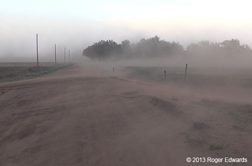
As we approached via southwesterly zigzag, the cluster seemed broad and disorganized with some updraft area on the south and east sides. When we stopped, S of Protection, the updraft area obviously was getting undercut by outflow, and the high-based, multicellular mess started its predictable forward-propagational heave. Cold outflow blasted past us to the E and SE, and a weak gustnado buzzed eastward across a field to our NE.
Dust rose from roads and fields, jacked skyward and forward in dense plumes, scenes from the Grapes of Wrath swirling through our minds as ribbons of fine soil blasted past. J-Hawk photographed and sepia-toned two of us pathetically immersed in the lofted dirt.
Massive dust-bombing wasn’t why we drove over 200 miles, though it did offer its own interesting photographic adventures. Nonetheless, this was the hand we pulled from the deck. Richer moisture did move into the inflow layer of this storm complex, but by then it evolved into a raging, N-S squall line that ate up every other convective attempt in its path (including the tornadic Rozel supercell that had gotten entrained into its N edge). One last view of the convection at sunset, from near Camp Houston OK, and it was time to plod home, regrets over choosing the “wrong” storm tempered by hopes for the next couple of days of potentially significant tornadic potential closer to home.
Early Father’s Day Gift…of Storms
May, OK
3 Jun 12

SHORT: Intercepted splitting, intermittently severe thunderstorms in NW OK.
LONG: This would be the inaugural day of Elke’s and my annual Great Plains vacation together, and as always, one brimming with hope and anticipation for two weeks of adventures across whatever lands the atmosphere lured us. The medium-range pattern suggested (ultimately correctly) that we would be spending a good deal of time in the Dakotas, Wyoming and western Nebraska. Until then, and along the way there, we had this risk for high-based but potentially severe and photogenic storms in northwest OK and southwest KS.
Overnight MCS action had left a morning outflow boundary from southwest AR through OKC to the northeastern TX Panhandle. A departing MCV aloft, followed in close order by a weak 500-mb shortwave trough, would yield only subtle shifts in the muddled large-scale support for convection over the area near the dryline-outflow intersection. Deep-layer flow was modest; so some storm-scale help would be needed to even get sustained rotation. Nonetheless, it was a chance for a scenic storm along the way to future days’ chase chances, and in the company of friends.
David Fogel’s dad Bob happened to be in OKC for a wedding the prior day, and joined him, Keith Brown and the two big dawgs for the afternoon to see firsthand this long-described phenomenon of storm observing on the Great Plains. It was a great pleasure to meet Bob at long last, and to share a chase day with him. We all headed out of OKC and up the Northwest Passage, stopping for automotive, human and canine fuel in Woodward as towers erupted to the NW. We intercepted what became the most interesting and persistent area of convection near May, a little bitty splitting updraft pumping out a great big anvil.
It was a rather easygoing and relaxing scene–a good one for Bob and DF to savor before they had to return to OKC for Bob’s flight the following morning. The dawgs seemed more interested in relaxing than in the storm, but they were well-behaved and apparently didn’t fart too much.
As for the storm, it drifted S, then split some, then propagated back NW, expanded, and dissipated, as we maneuvered around the May/Buffalo/Laverne area. When it became obvious the convection was falling apart, we bid farewell to the Fogel men, Fogel dawgs and Keith, and headed toward DDC to spend the night. Along the way, we found a line of utility poles apparently tilted by severe winds at some recent time, with replacements already in the ground.
Dinner and lodging (and even the faucet water) were lousy; so we made haste out of Dodge the next morning on the road northward to what proved to be a very enjoyable two-week sojourn over the blue highways of Middle America.
Spring 2011 Grand Finale: A Tornado-fest
Filed under: Summary
NW KS to south-central NEb
20 June 11

SHORT: Food, fishing, baby-bird rescue and a bunch of tornadoes…on final chase day of the vacation and season for us, with three tornadic supercells in northern KS and southern NEb.
LONG: Awakening to a windy, moist, scuddy morning in Alma, NEb, beneath a rip-roaring ENEly low-level jet, Elke and I knew this could be a productive storm day, but had no idea that it would land in the top few of our entire storm-observing careers. Indeed, if you include the calendar day–having witnessed the second of two spectacular, lightning-illuminated supercells after the stroke of midnight (story here), there is no question that his goes down as an all-time top-5-class chase day for either of us.
Pre-storm
After looking at morning charts, I targeted two plays:
1. Mid-day tornado potential in the “bent back” region of the occluding surface frontal zone, W of the dryline and near the surface low. Even by mid-morning, this regime was taking shape in west-central KS and moving directly N toward us, with only some diurnal heating and a storm needed to engage intercept mode.
2. Late-afternoon potential on the nose of the dry punch, near the dryline/warm-frontal triple point, over east-central or SE NEb. This is the regime I had in mind for a couple of days, but forecast backing of flow with height in the midlevels (a harbinger of linear storm modes) had me concerned.
Obviously, given where we were, #1 was a no-brainer as first choice, despite my historically lame fortune with “cold core” supercell regimes. If that option either busted or died out early enough in the afternoon, the rather slow eastward component of the deep-layer cyclone’s motion meant we could blast east, preferably on a road suited to it like I-80, and intercept the dryline storms.
With that strategic concept in mind, and a lack of food options in Alma, we headed for HDE to eat late breakfast/early lunch, then to a nearby city park to bide some time reading (Elke) and fishing (me) before storms went up.
I didn’t get too many casts into the lake because of a sad sight I found underneath a tree: two dead baby robins, blown out of their nests by one of last night’s supercells, and one still alive and shivering with hypothermia. After some deliberation about what to do, we noticed other robins and nests up the tree. Elke, who has a longstanding soft spot for baby birds, warmed the featherless little critter while I shimmied up the tree in search of a suitable nest in which to place the orphan. We got it in a snug nest (albeit alongside a much larger and older baby), hoping its new sibling could keep it warm and the new mama would feed it. Chances are it didn’t survive; but we tried.
First tornadic phase: “Long Island/Stamford” supercell
During the avian-rescue experience, a storm had formed (early, as cold-core storms often do) and quickly had become supercellular near HLC. By the time I got a good radar read on it, the storm already was tornado-warned. Though it was moving our way, we still were in HDE, well to its NNE, so…back S through Alma we went, and across the KS line. Mike U already had seen his festival of tornadoes by the time we caught the storm S of Long Island KS, but it was far from done.
Terrain in the area was somewhat choppy and frustrating to navigate, so we settled for the first decent hilltop view we could get, 3 S of Long Island. The supercell was moving toward the N and NNE at various times, with dark murk inside, a tall precip cascade on its SE (rear-flank) edge, and clear, blue sky to its E (our SE). Surface winds blew from the ENE to NE, as they would throughout the duration of our engagement with this supercell. We and the storm were a little leftward of the track of the surface low!
In the murk–and curiously, in the forward-flank interface region ahead of the main mesocyclone, we saw a small, tightly rotating wall cloud emerge, with a pencil-shaped tornado dangling beneath (photo: as seen and super-enhanced versions).
The tornado lasted about three minutes and dissipated, before a different, seemingly shallow, front-flank mesocirculation started spinning like mad to our W. That planted a dusty multivortex, which also was low-contrast (photo: as seen and super-enhanced versions). Whoa! I had based our intercept positioning, relative to the supercell, on the likely track of the primary mesocyclone, which stuck out eastward from the SE side of the north-moving storm.
By now, I had figured out what was going on, but that didn’t make it any less surreal. Pearls of enhanced rotation were forming and spawning front-flank tornadoes, along a necklace of very rich vorticity characterizing the inflow-outflow interface. A conceptual model of the situation looks something like this 2-D cartoon. Why this supercell was going nuts with front-flank mesocirculations, whilst most others don’t, is a question I’ll leave to the numerical modelers for the time being. In the real world of a storm intercept, this presented a strategic quandary, in that getting closer to the front-flank tornadic necklace also meant getting in the path of a rain-wrapped HP mesocyclone of a fairly fast-moving supercell.
As the second tornado churned northward, in step with storm translation, another suspicious feature caught our attention (Elke actually saw it first). A wide view of the storm (photo: as seen) shows the precip-wrapped, main mesocyclone to the left, and at far right, the dusty multivortex. Right before taking that shot, we spotted a dark, smooth, persistent, and reasonably wide lowering in another area of front-flank rotation, buried somewhat back into a precip-filled notch. That made ground contact, with rapid rotation of cloud material above and around the tapered-barrel shaped tornado. We had two ongoing, plus one that likely was underway in the main mesocyclone but not yet visible. More on that beast later. As for the two we knew, the arrows point to the visible tornadoes in this super-enhanced/zoomed version of the last shot.
We had a peculiar situation at hand.
After a few minutes, we lost sight of the southern front-flank tornado as it buried itself in precip, while the leading one narrowed and proceeded toward the N. We headed N too, crossing the KS/NEb state line about the same time as the leading tornado to our W (photo: as seen and super-enhanced versions).
Once that dissipated, we still had an original, dominant mesocyclone to our SSW, in which we couldn’t see anything thanks to persistent, rotating moat of heavy precip that cloaked the mysterious tempests of danger lurking within. This situation was getting weirder all the time, and was about to become truly bizarre.
I drove through Orleans and a few miles NW on US-136, which angled us closer to the front flank and somewhat in the path of the big meso. Lo and behold, just ahead of the rain-wrapped main meso, a tall, skinny, dusty tornado came into view to our WSW (photo: as seen and super-enhanced versions). This definitely was separate from the previous tornado, and probably just S of the KS/NEb state line. Meanwhile, a new and relatively robust shear-zone updraft to our NW (separate from the dissipated dusty tornado #2) started spinning frantically, and beneath a shallow, bowl-shaped and rapidly rotating lowering, spun up another short-lived, dusty tornado (photo: as seen and super-enhanced versions)! After the latter tornado dissipated, the prior, dusty tube seemed to spin down gradually instead of roping out, as if it simply lost its will to rotate.
Whither the main meso? At long last, we started seeing the answer as a rapidly rotating, nearly ground-to-anvil column of rain and hail churned toward us. Something very menacing, dangerous and unsavory began to appear from within the whirling dungeon of heavy precip–a big fat tornado (photo: as seen and super-enhanced versions). Look behind and above the tree row. I think what we’re seeing here is not just the rain-wrapped low levels of the tornado (dark wedge below cloud base, with helical scud coiling about).
Also, note the convective column containing the tornadic circulation (and not much larger in width than the visible tornado down low!) bending above and to the right. This is NWward with height on a N-moving storm, looking SW. [Conceptually, turn your usual NE-tilt on an E-moving storm leftward 90 deg as in the 2-D cartoon ]. In essence, you’re seeing the tornado-cyclone from ground into the mid-upper levels of the storm, visually. Yes, it was convective-looking, but corkscrewing pretty fast visually. Alas, even the mid-upper part didn’t shed its cloak of rotating rain curtains for very long; mostly it had been a bear’s cage from ground almost to anvil, for much of this storm’s lifespan in my view. I’m glad the curtains parted just long enough to reveal this fascinating deep-layer structure–and of course the hefty hose beneath.
My question: Was this the continuation of the Mr. Umscheid’s wedge from way down by HLC, or a separate tornado? Some shots by Walker Ashley seem to indicate a smaller barrel====>cone tornado earlier in this meso’s lifespan, and farther SW in KS. If so, either
1. Walker;s tornado expanded again to a rain-wrapped wedge shown here, or
2. This was a new one.
Whatever the case, the main-meso tornado likely had been ongoing for a long time, given that we had observed tremendously rotating rain curtains around the area for many minutes. This clearly was a very large, well-formed and mature tornadic vortex by the time we finally could see it. The entire tilted cloud column was rotating rapidly.
Wrapping precip again obscured the tornado within two minutes, or about the time it crossed into Nebraska. Orbiting rain curtains continued around the mesocyclone for several miles N toward Stamford an perhaps beyond, until the entire supercell evaporated from below and died W of HDE.
I read reports of “skipping” tornado paths with this storm in this area, which is bogus on two fronts:
-
1. By definition, a tornado cannot “skip”. If it’s not on the ground, it’s not a tornado.
2. Semantics aside, there simply was no “skipping”. The various different tornadoes in this area near the border, lined up similarly, probably gave the illusion of “skipping” of damage.
After the initial storm died, we got fuel in HDE and then couldn’t flank the downshear Elm Creek storm. We knew it was tornadic based on spotter reports and the SRM signature, but it was planted squarely on the highway to our N, near I-80. The first storm had put us out of position to see the business end of the Elm Creek supercell, so we jumped on the Interstate with its 75 mph speed limit and pressed the pedal hard in an eastward run for the second target area.
Second tornadic phase: “Hampton and Bradshaw/Stromsburg” supercells
Visually, a series of deep, glaciating towers to our ENE-E-SE looked reachable and was growing. By the time we passed the HSI/GRI exit, an unbroken wall of dense cores loomed to the E on radar, their convective towers lit by a blend of direct and filtered sunlight. My hope was that, despite the linear mode, a “tail-end Charlie” would roll up toward I-80 after I could penetrate the line and get into the inflow air. Linear storms don’t tend to hurl gorilla hail; so I was at ease with cruising up to the back and shooting through a relative gap.
That’s exactly what we did, except that the southern part of the line was breaking up into more discrete (and disturbingly, rotating) cells right as we started the penetration. We took a pounding from marginally severe hail, gazing southward through precip to see if anything could show up in the nearest area of rotation S of the Interstate. As we cleared precip and a ragged base came into view adjacent to the core, Elke saw a brief needle funnel 4/5 of the way to the ground. That might have been a tornado; though flooded fields precluded appreciable dust generation. No debris was visible beneath.
As we neared the Hampton exit, another core loomed to the SSE, moving N. We continued to press E, getting pounded by still more hail. Clearly the line had broken up into closely-packed supercells and we needed to get out of their way! A few minutes after we cleared the N side of the intensifying precip area, I glanced behind us to see a barrel-shaped, rain-wrapped tornado in the S part of the same core, about to cross the Interstate (photo: as seen and super-enhanced versions). That was a little too close for comfort, though we really had about 5 minutes’ cushion. I pulled off the road, jumped out, and gestured wildly at some westbound traffic not to go that way. Fortunately, they slowed down and pulled aside.
What appeared to be a big, low-visibility and significant tornado (as it turned out to be!) was almost upon the Interstate (photo: as seen and super-enhanced versions), and I was hoping nobody would drive into it. Enough precip wrapped around the tornado that we couldn’t see it with our eyeballs as it crossed I-80 (photo: as seen and super-enhanced versions), though it narrowed somewhat to a stilted stovepipe and became more visible again between I-80 and US-34 (photo: as seen and super-enhanced versions).
The Hampton tornado appeared to hook NNW and move away from us. Our last view of it (photo: as seen and super-enhanced versions) came with a troubling realization: we still were getting peppered with precip, including increasingly large hail! The real tail-end Charlie still hadn’t reached I-80 yet; and indeed, another core was moving overhead with a low base diffusely visible to our SSE. Time to high-tail it east again! As we pondered getting off the Interstate at the Bradshaw exit, Elke looked out and up to see rapid cloud-base rotation nearly overhead, atop that very exit. We kept going!
Behind and slightly leftward of us, the tornado first appeared in the rear-view mirror while driving out from under the meso. A small dust plume spun up just N of I-80. Above that loomed a rotating cone funnel that extended about 1/3 down from cloud base. We zipped a mile or so E, then pulled safely off the road to watch. This tornado was highly visible and quite photogenic, a marvelously sheathed column into which the condensation funnel seemed to poke, spike-like. “Finally,” I thought, “all these tornadoes today and we have a high-contrast specimen!” I said something more coarse, but fortunately, cannot recall precisely what.
Without an immediately available north road, we watched for a few minutes as the tube widened and retreated northward away from us, a wide-angle view revealing more of the tail-end supercell’s swirly updraft structure. Although rather distant, we had the tornado in view all the way through JYR and up US-81 to a point 4 ESE of Polk, where we pulled over briefly to watch it rope out to the WNW. This was our longest continuous view of any of the day’s tornadoes: 18 minutes.
A new lowered base even farther N told me this storm wasn’t through with cyclic tornado production yet. As it was moving N rather quickly, slightly ahead of abeam to port side, the town of Stromsburg and its inevitable slowdown dead ahead, we had to get moving for any hope of seeing the next hose. A few miles S of Stromsburg, we saw the newest and last tornado of our day emerge from the haze, to our NW.
Of course, traffic slowed to a crawl in town, a chain of cars inching N at about half the posted 25 mph speed limit, some slowing down or turning indecisively as if thoroughly bewildered. Townsfolk stood in at least half the yards gazing in various skyward directions, not sheltered, despite the ominous wail of storm sirens. I thought, “They’re safe and don’t realize it yet; but if the tornado were headed into town, we would have multiple casualties amongst all these unprepared and confused citizens”. What I actually said might have been a tad less civilized, so it’s good that I can’t recall that.
By the time we got extricated from Stromsburg and headed N for a few miles, contrast improved enough to pull W half a mile and get a few decent shots, including this one looking NW across a corn field at the stout, grinding vortex. Motion of the ragged cloud base around the top of the visible tornado was impressively speedy. Driving a few more miles N on US-81, we finally got roughly abeam of the tornado again, only to see it rapidly narrow and then rope out.
Just in case the storm would cycle once more, we headed up an unmarked road off the east bend of US-81, in the general direction of Duncan. Alas, the supercell quickly displayed a rain-wrapped, outflow-dominant structure, and would produce no more tornadoes. We turned around to head back to JYR, photograph a couple of elevated cells (looking E and looking N from the S side of JYR), grab a room, and get some celebratory steak dinner before restaurants began to close.
Epilogue
A hearty meal was in order too. During a long storm-intercept day, we successfully had observed at least 8 and perhaps up to 10 tornadoes, from three different supercells, in two separate forecast targets and meteorological regimes. All I can say is, wow…only 3 May 1999 clearly exceeds this for my one-day tornado total. We don’t chase just to see tornadoes–far from it, actually–but you bet we’re appreciative of them for their rarity, uniqueness and power–the dichotomously ironic “Beauty of Atmospheric Violence” that is the title for my storm-photography shows. Best of all, nobody was injured through all the whirling mayhem of the day.
It was an amazing grand finale to an unprecedentedly bountiful 2011 Great Plains severe-storm vacation (and season)!
I had called in several of the tornadoes as soon as safety and cell signals would allow, a few while they still were underway. Within a couple weeks after we returned, I processed the day’s images (before all others from this vacation) and sent an itemized table of tornado times and estimated locations to the affected WFOs, with embedded links to many of the same photos as above. That table includes times, locations and links to the above photos. The tornado log file is in the public domain, and linked here in MS Excel format, freely accessible for anyone interested.